Historic Landscape
Characterisation
Merthyr Tydfil
013 Cyfarthfa Castle and Park
HLCA 013 Cyfarthfa Castle and Park Ironmaster's seat, historic
park and garden; visual connectivity to associated ironworks and industrial
extractive landscape; later museum and school; recreational area; historic
and artistic associations.
Click here for a
character area map
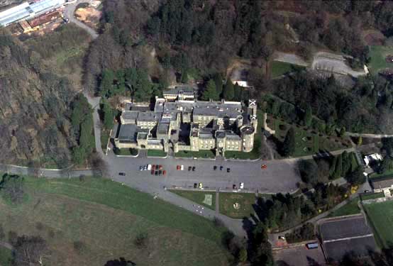
(Photo: GGAT Merthyr 013)
Cyfarthfa Castle and Park character area: ironmaster's house and park.
Summary
Cyfartha Castle was built in the second quarter of the 19th century as the home of the Crawshays, owners of the Cyfartha Iron Works. It was initially provided with an informal park in the Romantic style, but this had developed into a more formal layout by the late 19th century. The park, now recognised as a nationally important one, is now the largest open space in Merthyr Tydfil. The castle now combines the functions of school and museum. It remains an important example of an ironmaster's residence.
Historical background
The historic landscape area of Cyfarthfa Castle and Park is the largest open space in the Merthyr Tydfil conurbation, representing a mature designed landscape, graded as II* (Cadw/ICOMOS UK 1999, 95). The house was commissioned by William Crawshay in 1825, and was designed by Robert Lugar as a mock castle. The house (a Grade I Listed Building) overlooks grounds dropping to the southwest and the Cyfarthfa Ironworks, on the far side of the River Taff.
Initially, the surrounding parkland was Romantic and informal, but by the late 19th century a more formal layout as a landscape park had developed. There were two entrances, the southwest entrance originally had lodges but these had gone by 1873. The areas behind the house, to the east and north, have developed as mixed woodland. The 1875 6-inch OS map indicated an Ice House adjacent to the boundary wall of Castle Wood, north of the house.
The Fish Pond reservoir at the western edge of the area together with other reservoirs and leats within the park, supplied water to the Cyfarthfa Ironworks via a chute on the Pont-y-Cafnau Bridge. Other features of interest include the Upper Ponds; a series of four narrow elliptical ponds with stone-reverted dams on their northwest side arranged one above the other, and Bryn-Cae-Owen Pond (on the 1826 OS Surveyor's drawing) located to the northeast of the house.
Following the sale of the park to Merthyr Tydfil council in 1910, changes were made, including the creation of two terraces south of the main drive for a bowling green and tennis courts, and the construction of flower beds and a fountain. The Castle now forms the dual function of school and museum.
More recently, the east part of the park has been converted to school playing fields.