Historic Landscape
Characterisation
Merthyr Tydfil
009 George Town, Former Industrial Settlement
HLCA 009 George Town, Former Industrial Settlement Industrial
settlement area; remodelled in recent years but early regular street layout
maintained; transport corridor; 19th century religious buildings; historic
associations (Crawshays of Cyfarthfa; Joseph Parry.
Click here for a
character area map
(Photo: GGAT Merthyr 009)
George Town, Former Industrial Settlement character area: industrial
settlement now almost entirely redeveloped for modern housing.
Summary
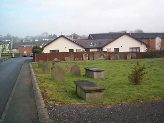
A redeveloped settlement originally associated with the Cyfartha Ironworks and developed in the early 19th century. The original housing has now largely been demolished and replaced by modern housing, but the settlement still retains its earlier grid layout; a historic survival is the graveyard originally attached to Bethel Chapel
Historical background
The historic landscape area of George Town, Former Industrial Settlement comprises the area of a former early industrial settlement to the west of the Glamorganshire Canal. The settlement was established during the early 19th century on part of the Dynevor Estate, leased to William Crawshay of Cyfarthfa.
During the 18th century, a single building, possibly an inn, was indicated and by 1814, a single row, to the southwest of John Street, was in place, as were a number of individual cottages.
Early OS maps and surveyors drawings and other plans chart the development of the area between 1814 and 1832. Starting with Dynevor Street, the area later developed to form a grid street pattern, including George Street and Nantygwennith Street, with individual cottages at street corners and along the west side of Nantygwennith Street. The street layout had been largely established by 1836 (though the rows were as yet incomplete) and comprised Trevor Street (Nantygwennith Street) and Dynevor Street, Chapel Street, Cyfarthfa Street, George Street, John Street, Richard Street, Parish Road, Iron Lane and Griffiths Lane. The areas in between were laid out as yards/gardens. The tramroad between the Glamorganshire Canal and the Ynys Fach iron works was in place by this date. The adjacent area (HLCA 014) contained warehouses, the canal office and Chapel Row with its octagonal chapel. South of Dynevor Street and north of Ynys Fach Ironworks was an area of three terrace rows within the vicinity of iron bridge' (Middle Lock Bridge). The housing within the area was complete by 1850 and two additional terraces had been erected to the west of Trevor Street north of Jackson's Bridge.
Further detail is provided by the OS First Edition maps of 1875 and 1878: indicating a tramroad between Cyfarthfa and the Ynys Fach Ironworks, which ran via the warehouses and timber yards near Chapel Row. Other features of the period include a smithy, the Cyfarthfa Schools, a tannery and on the far side of the canal, the Taff Vale Brewery. Later additions are primarily the addition of schools in the area of north of Nantygwennith Lane (Parish Road) replacing a row of industrial cottages. The area also boasted the usual church and chapels: Christ Church (1857 by J Benest), a Welsh Baptist chapel on Dynevor Street, and Bethel Independent Chapel (pre-1836).