Historic Landscape
Characterisation
The Rhondda
005 Trelaw
HLCA 005 Trelaw
Composite colliery settlement, 1st phase pithead settlement, small compact
nucleated colliery-built settlement of linear terraces with extensive
later ribbon accretions; retains typical terraced housing, and chapels,
etc.; residential colliery village with building-club, speculative and
owner-occupier housing; large cemetery serving surrounding area, including
lower and mid-Rhondda Fach; low commercial development.
Click here for character map area
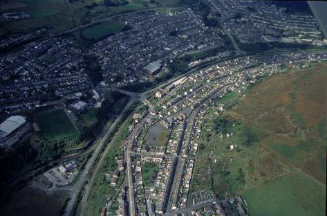
(Photo: GGAT HLCA005)
Aerial view of Trealaw from the south-east.
The historic landscape area of Trealaw first appears on the first edition 6-inch OS map surveyed in 1875, located along the slopes to the south of Brith-weunydd Colliery with the Miskin Hotel at the southern end of the settlement. While some attempt has been made to regularise the street layout of the settlement, the cottages and large gardens appear similar to those typical of early and unplanned ribbon development. During the period Trealaw attracted the attention of the Local Authority for its poor sanitary conditions, in particular Miskin Road with its high density of 'cellar' dwellings. The colliery and settlement had been constructed on Ynis y Graig (also named as Ynys Crug) and Berth-weunydd Uchaf farms. The Tithe map of Ystradyfodwg 1844 indicates that the property was then held by executors of Anne Saunderson, and leased to Walter Coffin, the early coal entrepreneur. The early exploitation of the coal reserves of the area was initiated and developed by Walter Coffin from Brith-weunydd Level (1839-1879), and Gellifaelog Colliery (1845-1868) on the neighbouring Dunraven Estate and the nearby Dinas Middle Colliery (1832).
By 1898 Trealaw has expanded in linear fashion northwards along Ynys Cynon Road and to the southeast along Brith-weunydd Road to the impressive Llethrddu Cemetery. Apart from the cemetery with its mortuary chapel, Trealaw could boast a church, All Saints, chapels, schools, a Mission Hall and the Bute Hotel at this date (2nd edition 6-inch OS map, 1901, revised 1898). Further expansion occurred in the period up to 1915, chiefly the extension of Trealaw Road and construction of housing both above and below Brith-weunydd Road, immediately west of Llethrddu Cemetery and east of Nant Brith-weunydd. The latter addition comprised a planned street layout on a grid basis complete with infant school (1921 edition 6-inch OS map, surveyed in 1914-15).