Lower Wye Valley
016 Tintern Parva
HLCA 016 Tintern Parva
Medieval/Post-medieval settlement: nucleated cluster, ribbon development and dispersed farmsteads and cottages; relict archaeology: medieval and post-medieval settlement/fields; monastic (former manor/Hospice at Tintern Parva); 19th century settlement features/building types (place of worship, police station, public houses); communication features; Medieval/Post-medieval ecclesiastical (church and cemetery and non-conformist chapel); varied agricultural field pattern, some amalgamation, other areas reverting to scrub woodland; Ancient Woodland; industrial archaeology (malthouse, smithy and wharf). Back to map
Historic Background
The historic landscape area of Tintern Parva is an area of settlement on the western riverbank of the Wye north of the Abbey at Tintern. The area is currently designated as a Conservation Area.
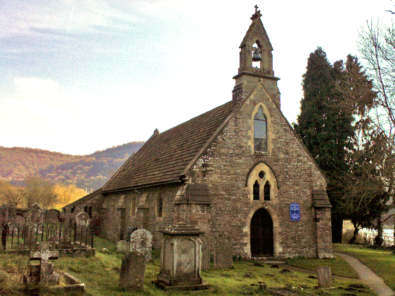
The earliest evidence for activity in the area dates to the medieval period with the church of St Michael and All Angels at Tintern Parva first mentioned in the Book of Llandaff in c. 1348 (Brook 1988, 84). The irregular polygonal churchyard is also indicative of an early ecclesiastical foundation and the form of the earlier settlement, a nucleated cluster centred on the church, also suggests a medieval origin. Apart from the existence of a medieval wayside cross (no longer in situ), there is little other readily available information on the early history of the area. The First Edition OS map indicates the remains of an 'Old Manor House' at Tintern Parva just to the west of the cross roads, a little distant from the church. The map depicts the remains of a large rectangular enclosure and other structures at the site, and also gives the name Hospice House to a structure nearby. Further investigation and study is needed: this is probably the site of a manor belonging to Tintern, and possibly an alternative site for the 'Secular Firmary Grange' usually identified with an area slightly further to the southwest (see HLCA009).
The modern A466, which runs through the area, appears to follow more or less the line of the first turnpike road to run through the Wye Valley. The turnpike road was opened in 1829 following much debate: Valentine Morris is quoted as saying at one of the hearings, concerning the construction of the road, that it was a necessity as everyone in the Wye Valley was forced to 'travel in ditches' (Howell 1985).
Agri-industrial industry, specifically the processing of cider was prevalent throughout the area from the medieval period onwards, but at Tintern Parva specific evidence exists for this activity in the form of the Old Cider mill (PRN 03780g). It is further evident in place name evidence that this cider production industry played an integral part in the areas agri-industrial history, as can be seen in the 1844 tithe and apportionment where numerous land holdings are referred to as 'orchard' or 'grove'.
Historic Landscape Characteristics
Tintern Parva is characterised as a nucleated settlement with linear ribbon development adjacent to the River Wye and to the northwest scattered cottages with associated irregular enclosures, the latter now in part reverting to scrub woodland.
There has been significant settlement expansion in the character area since the compilation of the tithe in the mid-nineteenth century. Originally a small, nucleated settlement cluster was centred on the medieval church at Tintern Parva with its cemetery and the Village Inn, the Carpenter's Arms. In addition a strip of ribbon development extended along the river's edge and the road from Chepstow to Monmouth. The ribbon development is located on a narrow strip of riverbank and constrained by both the river and the adjacent slope. Today the settlement at Tintern Parva includes an area of social council housing (Park Glade) and small-scale private development off the road, which runs north to Trellech. During the nineteenth century, settlement along this section of road had been limited to a few isolated cottages, with land use recorded as orchard, meadow and pasture in the 1844 tithe apportionment.
While ecclesiastical activity is evident from the establishment of a church and cemetery here in the medieval period and by the later location of a monastic manor, the overriding characteristic of the area is its post-medieval settlement, which is essentially a road and riverside settlement. Some traditional vernacular buildings exist, but the settlement is generally late nineteenth century in character. The development pattern is characteristically of single houses and informal rows, then smaller cottages alongside villas, which have more of a suburban character. The influence of the Crown Estate is reflected in the building stock (eg Wyedene). The significance of area in earlier twentieth century tourism is perhaps flagged up by Wye Valley Hotel, of c1920.
The area's small, detached cottages, a few, notably near the church, are set tangentially to the slope in the older vernacular tradition. It is just possible that these had medieval precursors. To the south on the narrow river terrace ribbon-like development leads south towards Tintern. This is likely to represent settlement expansion linked to the construction of the toll road in 1829, and comprises a few nineteenth century villas (eg Ash House), a number of closely spaced cottages (eg. Melrose Cottage and Wye Cottage), public houses (eg. The Rose & Crown), a police station and post-office and a few possible commercial buildings (First Edition OS map). The First Edition OS map shows a short row of industrial workers' housing adjacent to the church within the core of the old village on the lane leading to the wharf.
Elsewhere, there are a number of dispersed isolated farmsteads and cottages. Most of the farmsteads depicted on the First Edition OS map are small, little more than cottages, usually a single rectangular range, effectively smallholdings (eg Hill Farm, and Barbadoes Green), associated with evolved irregular fields. It is noticeable that much of the irregular fieldscape is depicted as woodland/scrub or orchard. The Catbrook Road area retains small vernacular cottages (eg Rose Cottage retains tiny windows) and a scatter of others up the valley though mostly extended and altered. The area also has twentieth century housing estates of c1970 and c1950-60. The Botany Bay area has further small cottages in informal settlement pattern, and some estate cottages (stone and brick), generally nineteenth century in date. The small area of relict stone field walls at Botany Bay is also worth a mention.
The exception is a single isolated farm located some distance to the northeast down a sinuous lane, 'The Nurtons'. This is depicted on the First Edition OS as a detached farmhouse with a large linear agricultural range to the east, among other buildings, and an orchard and old quarry to the northeast of the farm complex. The whole complex is set slightly off-centre within its own consolidated holding of largely regular fields, probably amalgamated fields with boundaries neatly laid out. This holding, which extended to the banks of the Wye, appears to have been the best land in the area.
The principal building materials in this area are generally of rendered stone (locally sourced quartz conglomerate and sandstone) and brick, the latter generally used for more recent additions to the settlement. The principal roofing material within the area is characteristically of slate and pantile.
The area contains indications of its agri-industrial past, with a now listed cider mill (LB 2752 Grade II) believed to be of nineteenth century date recorded on the 1844 Tintern Parva tithe map. The mill was converted into a house in the late 1970's and was extended considerably, though much of its original structure has survived unaltered. Most of the original milling machinery is intact despite conversion. The survival of cider making machinery in-situ is now extremely rare despite its former frequency in this area, an agri-industry which initially had roots associated with the Abbey at Tintern in the medieval period. Another example to survive is the Old Cider Mill (PRN 03780g) along Trelleck road unique in its level of preservation and retaining its horse driven cider mill and press on the ground floor.
In addition to cider milling it is likely that a range of cottage industries, crafts and other agri-industrial processes were carried on in the area, as in most rural communities prior to the end of the twentieth century, the name of the public house near the church being the Carpenter's Arms (First Edition OS map). The First Edition OS map, for example, indicates that small scale quarrying was carried out in the area from at least the earlier part of the nineteenth century, with an old quarry near the farm of Nurtons, and one further to the south possibly still active at the time, near Tintern Station and the Wye Valley Railway. The same plan indicates a smithy, and wharf, near the church and a malthouse located in the linear southern extension to the settlement. It is likely that the wharf at Tintern Parva was an important communication feature prior to the construction of the Turnpike Road in 1829, and also would have been a disembarkation point for travellers undertaking the Wye Valley Tour during the eighteenth and early nineteenth centuries.