Margam Mountain
015 Upper Park and Ton-y-grugos
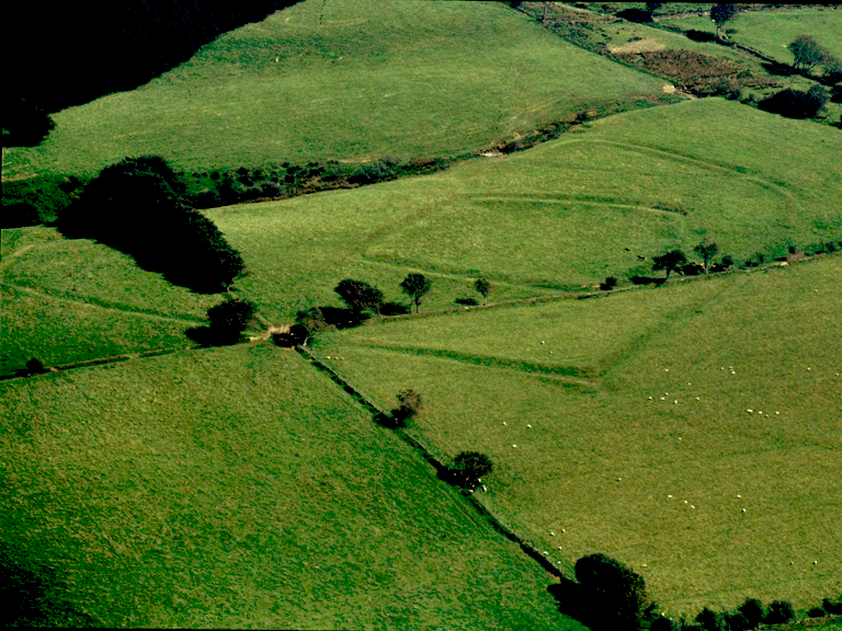
HLCA 015 Upper Park and Ton-y-grugos
Enclosed upland grazing: large regular enclosures; distinctive field boundaries; relict archaeology: prehistoric, medieval and post-medieval settlement/fields; prehistoric enclosures (upland agricultural landscape features); buried archaeology: parchmark. Back to Map
Historic Background
The historic landscape area of Upper Park and Ton-y-grugos encompasses the former Upper Park, part of the Margam Estate's former post-medieval deer park; the area is identified as distinct and separate from the rest of Mynydd Margam, enclosed by at least the early 19th century, if not before. The enclosure, which surrounds the western part of Upper Park from that immediately north of Ton mawr, appears to respect the lines of early intrenchments or hollow ways; a medieval or earlier date for the boundaries could be postulated and these may even reflect the line of earlier stock controlling barriers associated with adjacent late prehistoric enclosures.
Between 1814 and the 1870s the western part of the park has been further subdivided along regular lines by 'cloddiau' or stone-faced banks into rectangular enclosures. Place name evidence also suggests the established use of part of the area as layland (Ton-y-grugos); the area is shown partly enclosed at the time of Hall's estate survey of 1814, fully established by the publication of the first edition OS.
The overriding significance of the area, however, is based on its relict archaeology: specifically the nationally important prehistoric 'defended' enclosures, the camp E of Ton mawr and Caer Cwm Phillip (both scheduled) and numerous entrenchments or hollow ways of some antiquity.
The location of the post-medieval cottage of Ty'n-y-parc on the edge of the enclosed land adjacent to Ton mawr and along side the track to Llangynwyd is interesting and is typical of a squatter or landless estate worker's settlement.
Historic Landscape Characteristics
Upper Park and Ton-y-grugos is characterised by enclosed improved and semi-improved upland grazing (formerly deer park associated with Margam Park) set out as large regular enclosures with distinctive field boundaries, including hedge banks, cloddiau and drystone walls. The area is an important relict landscape with characteristic fields and associated settlement dating to the prehistoric, medieval and post-medieval periods. The prehistoric settlement element comprises exclusively 'defended' enclosures, such as the scheduled single-banked enclosure or camp to the E of Ton mawr (SAM Gm 090) and the angular defended enclosure of two polygonal banks with annex, known as Caer Cwm Phillip (SAM Gm 057), both of which date to the Iron Age. Aerial photographs indicate other associated features surviving as parchmarks. The area is closely related to the adjacent area to the northeast, HLCA013, not only in terms of prehistoric settlement/agricultural use, but also by common usage as a communication corridor from the prehistoric period to post-medieval period connecting Margam with Llangynwyd, important centres from at least the early medieval period if not earlier. A particularly striking element of the landscape are the numerous 'intrenchments' noted on the 1st edition OS map extending SW-NE through the area; dates ranging from prehistoric, early medieval and medieval has been postulated for these features which appear to represent a mixture of hollow ways or trackways and possibly stock controlling barriers. The Moel Ton Mawr Tramway (2nd edition OS map 1900) demonstrates the continued importance of the area as a communications corridor during the 20th century.