Margam Mountain
013 Upper Cwm Kenfig
HLCA 013 Upper Cwm Kenfig
Multi-period and multi-functional upland landscape with important relict archaeology: prehistoric and medieval settlement/fields, prehistoric funerary and ritual landscape, prehistoric enclosures (upland agricultural landscape features); accumulation of blanket peat with environmental potential; important prehistoric and medieval communication corridor. Back to Map
Historic Background
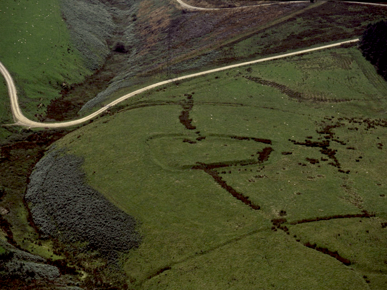
The historic landscape area of Upper Cwm Kenfig comprises a remnant of a formerly much more extensive area of upland grazing, part of the Margam Estate during the post-medieval period and previously held by the Cistercian Abbey of Margam. The most visible remains in the area are relict prehistoric and medieval features, such as the impressive Iron Age Camp or Hillfort of Caer Blaen y Cwm (SAM Gm 58; RCAHMW. Glamorgan Inventory, Volume 1, Part 2), which dominates the upper portion of Cwm Cynffig, the Kenfig Valley. This site is one of a number in the vicinity, which appear to be controlling access between the valleys, ridgeway routes and the higher pastures of Mynydd Margam.
Finds of flint tools (PRNs 05028w; 05029w; and 02102w) dating from the Mesolithic to the early Bronze Age, and several funerary and ritual features, specifically, burial mounds or cairns of Bronze Age date, such as Twmpath Diwlith (PRN 754w), among several excavated on behalf of the National Museum of Wales in 1921 (RCAHMW. Glamorgan Inventory, Volume 1, Part 1), indicate a considerable period of use if not occupation, prior to the establishment of the hillforts of the area during the late Bronze or Iron Age.
Other characteristic landscape features within the area are the ridgeway routes, such as Heol-y-Moch, and Ffordd-y-gyfraith, (also known as Cefn Ffordd); the latter runs along the ridge of Mynydd Margam via Rhyd Blaen-y-cwm and southeast towards Mynydd Baedan (RCAHMW 1976, Vol I, II). The area is also crossed by the route of the former parish road from Taibach to Llangynwyd via the 'Cross of the Hand' (George Yates Map of 1799); this 'diverted' (ie closed off to public use) in 1829 to avoid crossing Margam park. Many of the stretches of 'intrenchments' (1st edition 6-inch OS map) and holloways in the area can be interpreted as the remnants, and variations, of these important routes.
Historic Landscape Characteristics
Upper Cwm Kenfig is characterised by its enclosed and partly semi-improved pasture. The area represents a surviving fragment of the once extensive open upland grazing of Margam Mountain. The overriding characteristic of the area is as an important surviving relict archaeological landscape with a long continuity of use. The area is a multiperiod, multi-functional upland palimpsest, which comprises prehistoric and medieval settlement/fields, prehistoric funerary and ritual features, including burial cairns of the Bronze Age, eg Twmpath Diwlith and prehistoric enclosures, upland agricultural landscape aspects, such as Caer Blaen y Cwm Iron Age Camp or Hillfort (SAM Gm 58) with associated hollow way and crossridge dyke. Other relict features include prehistoric and medieval trackways, such as Heol y Moch, Ffordd-y-gyfraith, while industrial features, such as quarries, associated tracks and a tramroad (2nd edition 6-inch OS map) attest to characteristic exploitation of the uplands during the post-medieval period. The area also contains buried archaeological remains in the form of parchmarks and find-scatters.
It is considered that impact of clearance and climatic change towards the end of the Bronze Age resulted in environmental conditions conducive to the formation of blanket peat; this affected the dissected plateaux of Mynydd Margam as elsewhere in the upland Glamorgan (Caseldine 1990); potential exists for survival of environmental and other indicators associated with the Bronze Age and earlier landscape.