Gower
073 Ilston Valley
HLCA073 Ilston Valley
River valley landscape: ancient woodland; agricultural industrial landscape with medieval origins: milling; linear settlement cluster; and non-conformist chapels. Back to Map
Historic Background
The historic landscape area of Ilston Valley represents an area of enclosed river valley, which includes the two settlements of Parkmill towards its western extent and Stonemill at a confluence to the southeast, near Kilvrough Manor. The area lay at the boundary of several medieval manors including Pennard with the fees of Lunnon and Kittle, with Penmaen to the west. The whole area fell within the Welsh medieval Cwmwd of Gwyr, within the Cantref of Eginog. During the reorganization of the post-medieval period the area formed part of the Hundred of Swansea, within the County of Glamorgan.
Little is known of the area's development prior to the medieval period, and evidence for the medieval period is largely limited to the site of the medieval chapel of St Cenydd (00315w; 305581; SAM GM158) and the near by Trinity Well (00316w; 32363; SAM GM158; Jones 1954, 184), though the use of the area for milling is also known to date back to the period.
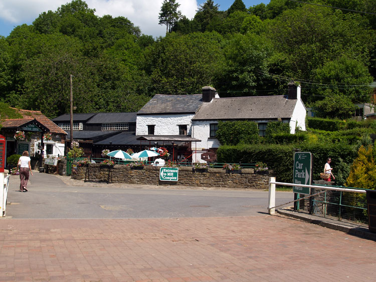
The origin of Park Mill (02131w; 24961; LB 11726 II) goes back to the early Middle Ages, and there are references from about 1300. The name refers to the adjacent park of the Le Breos family. A resident miller (Phillip Longe) is first mentioned in 1428, together with mention of a millpond and mill machinery; the present building is considered to incorporate the remains of the original medieval structure. In 1585 the mill became part of the Kilvrough estate and a survey of 1650 refers to 'two water grist mills called the Parke Mills', let for '£15 annually, to which farm tenants still owed suit.' The millers at the time were a Jenkin Ffrancklen Richard David and Edward Price. The second mill referred to was 'Stonemill' (02085w; 02087w; 24962), which is shown on Colby's map c1830, though now converted (Taylor 1991, 10-11).
Parkmill mill was tenanted and operated by William Davies during the late seventeenth century; Davies's descendants continued as millers until the twentieth century, some of them noted characters in Gower history. Little change is noted throughout the eighteenth century, with two corn gristmills mentioned in the 1764 Survey; this also mentions a pound at Stonemill, and at Parkmill a small adjoining house and garden were in existence, together with a kiln for drying oats located under the cliff opposite.
During the nineteenth century the adjoining miller's house appears to have been reconstructed and whilst corn and animal feeds continued to be processed, the business of the mill was extended to include sawing, carpentry, wheelwrighting (c.1860), and in 1912 a smithy (41185) was added. John Davies acquired the freehold of the mill in 1920 from the Kilvrough Estate. The mill, electrified during the 1950s, ceased to grind corn in the 1960s, and carried out other operations in 1983. The site was sold in 1989 and a Trust 'Y Felin Ddwr Crafts and Countryside Centre' was established to preserve the surviving nineteenth century machinery; the premises currently operates as the 'Gower Heritage Centre.'
The settlement at Parkmill was expanded during the nineteenth century and additions included Trinity Well Baptist Chapel (11821) and Mount Pisgah Chapel (01484w; 9626; LB 11735 II); the latter built in 1822, was the last of six built at the expense of Lady Diana Barham, the benefactress of the evangelical movement, who came to live in Gower in 1813. Mount Pisgah chapel became Independent in early 1823, following the development of a rift between Lady Barham and the Calvinistic Methodist movement. The design is more architecturally ambitious than the others, and has a classical Regency character with its stuccoed finish and separately roofed pavilions on each side (Newman 1995, 367).
The nearby Gower Inn was also in existence by the publication of the first edition 25-inch OS map, as was the former school and schoolmaster's house (305496; LB 23537 II), built in the Tudor and Elizabethan revival style in 1876 to the design of J H Baylis of Swansea, architect, for Thomas Penrice of Kilvrough. The building is now an activity centre belonging to the West Glamorgan Guides (Newman 1995, 367).