Gower
062 Southgate
HLCA062 Southgate
Post-medieval agricultural settlement, and later twentieth century settlement landscape: dispersed farmsteads/cottages now dominated by 20th century ribbon development and estate infilling, post-medieval vernacular architecture; and twentieth century coastal type housing including villas. Back to Map
Historic Background
The historic landscape area of Southgate is an area of settlement defined by the extent of present modern village, which include elements of earlier post-medieval settlement. The associated well-preserved medieval/post-medieval agricultural landscape lies within the adjacent HLCA 061 and has been dealt with separately.
Roman finds have been recovered from near Sandy Lane and the general area has early medieval associations with the site known as Llan Arthbodu (00328w and 05260w); a grant of four pieces of land: 'cellam quidem Cyngualan cum sua tota tellure and Cella Arthuodu, Congurique and Penncreic' by Athrwys ap Meurig to Bishop Euddogwy (Davies 1979, 97), a possible monastic cell mentioned in the Book of Llandaff [LL 144; c.650] has been tentatively associated known as Bodies Acre on the tithe map, though this is strictly beyond the limits of the area (Evans 2003a, 2004).
The area formed part of the demesne manor of Pennard from at least the thirteenth century. Pennard is mentioned in 1353, in a list of among 25 fees, assembled by Mowbray, the then Lord of Gower (Nicholl 1936,168). The adjacent burrows at Pennard were known to have already been in existence by 1316 when William de Breos granted his 'sandy waste' to his huntsman William (Lees and Sell 1983). The advance of the sand was gradual, but appears to have eventually forced the final abandonment of the earlier settlement of Pennard in the sixteenth century (see HLCA 058). The old settlement with its church (St Mary's) and Castle, dating at least to the thirteenth century, later became a rabbit warren, and has more recently been re-invented as a golf course. The current church of the settlement, St Mary's Pennard, though a medieval foundation (00327w; 400053; LB 11537 II), lies at some distance from the modern settlement of Southgate within HLCA061 (Davies and Toft, 1993; Newman 1995, 505-6).
Hardings' History of the Parish of Gower gives a description of the manor from a survey of 1745, whilst the Gabriel Powell Survey of 1764 gives the same details, mentioning a dependency on agriculture and inshore fishing (Harding 2000,11-12; Morris ed 2000, 139-142). During the eighteenth century the general area was associated with smuggling, with a certain William Arthur, tenant of Great Highway Farm (within HLCA 051) between 1783 and 1794, being the notorious leader of a gang of smugglers.
Southgate and Pennard appears to have developed little in the way of industry, apart from limekilns and limestone quarries. The quarrying of limestone in the Manor is recorded in the Cromwellian survey of 1650. Limestone quarrying for agricultural lime production was carried out on a large scale during the post-medieval period to satisfy the increases in demand for corn and the corresponding need for land improvement during the 17th and 18th centuries. In addition to numerous limekilns and quarries, the first edition details minor agriculture related features such as saw pits (as at James Grove).
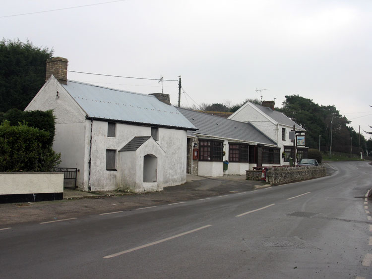
The settlement pattern/distribution of the area appears to be in place by the late eighteenth century, and little change is noted by the tithe, or indeed the survey of the 1st edition 25-inch OS map of 1879, apart from some minor accretions to the existing settlements, which appears to include a cluster at Southgate. At the north of the area are Sandy Lane House and cottage and the two opposing ranges of Norton. The main settlement of Southgate comprised the three ranges of Southgate Farm (house and garden, barn and stables on the tithe map of 1848, now demolished and formerly stood HLCA 058), Little Southgate Farm (02706w; 19140) and 10 or so crofts and cottages established in ribbon fashion along the lane leading north to the burrows, in addition to the homestead of Great Southgate (01758w; 18862), which is shown located slightly apart to the west with an opposing L-shaped range, is further expanded by the publication of the 2nd and 3rd editions of the OS 25-inch. This appears to be the only notable development in the settlement prior to the 1930s. Slightly further south of Southgate set adjacent but at right angles to the road are a small number dispersed cottages, possibly small 'failed' farmsteads of c.18th century origin established on stripfield landshares, during the period of reorganisation of the agricultural holdings into larger consolidated holdings; their layout dictated by the stripfield size and orientation. These include Broadway, Brinselway (18088), and Broad Pool Cottage.
By the mid-19th century the settlement remains set within a matrix of linear strip fields, remaining largely as unconsolidated holdings. Little change is noted in the pattern by the late nineteenth and first quarter of the twentieth century, thereafter the fieldsystem within the HLCA is progressively taken for building developments, such as 'the Drive' and 'Bendrick Drive'. During the 1930s temporary wooden holiday bungalows were erected here; by 1937 a survey records that 104 bungalows had been erected at Sandy Lane and 20 at Southgate, among others in the Pennard area. Following the three night blitz of Swansea in 1941, displaced inhabitants of the city occupied the holiday bungalows. During the 1950s and 60s permanent houses were erected at Southgate and Sandy Lane through compulsory purchase to erect council houses, augmented by private development (Harding 2000, 114-125).