Gower
029 Worm's Head and South West Gower Cliffs
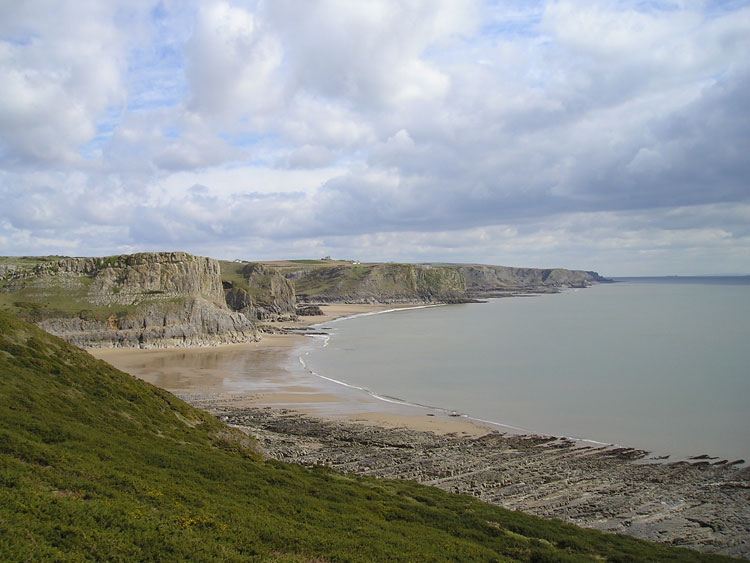
HLCA029 Worm's Head and South West Gower Cliffs
Intertidal zone, unenclosed coastal margin and cliff edge landscape: caves; prehistoric settlement and finds; maritime features; agri-industrial processing; historic associations; tales and legends; and livestock management. Back to Map
Historic Background
The historic landscape area of Worm's Head and South West Gower Cliffs encompasses the steep cliff slope as well as the open cliff top from Rhossili to Oxwich Bay and including Worm's Head.
A number of caves exist in the cliff face along this stretch of coast; some of these have provided evidence of habitation and even ritual activity dating back to the Palaeolithic. The most well-known is Paviland Cave (SAM GM504; 00118w; 300251), otherwise known as Goat's Hole; one of the most significant prehistoric sites in Britain, where the remains of an Upper Palaeolithic burial known as 'The Red Lady of Paviland' were uncovered during excavations in the early nineteenth century. This is in fact known to be the skeleton of a male in his mid twenties, radiocarbon dated to c.28000 BP. Evidence of ivory working in the Paviland cave group is confirmed by artefacts associated with the burial; over forty ivory cylindrical rods and ring fragments were found near the rib cage along with a large quantity of sea shells by the thigh. Bones of six individuals found in Mewslade Cave (00116w) possibly also date to the Palaeolithic given their association with a number of bones from extinct mammals.
Evidence of early Mesolithic domestic activity is found in the area examples include Foxhole cave (04797w-04802w; 300253); where a possible hearth along with worked flint and midden material were uncovered. Flint assemblages spanning a number of periods have been recovered; those of Palaeolithic date at Paviland cave are exceptional in quality and importance; Mewslade cave provides examples of Mesolithic finds (00115w; 305515). Neolithic flints and a possible inhumation were discovered at Red Fescue cave (02215w). Bronze Age archaeology is less substantial equating to only a small number of finds.
It was the cliff tops themselves that were the focus of activity during the Iron Age; seven known promontory forts are located along this stretch of coastline. Excavations of some of the sites revealed evidence of use continuing into the Roman period , for example pottery dating between the 1st century BC and the 1st century AD was found at Horse Cliff (00138w; SAM GM192). Some of these may also date from the early medieval period or were perhaps reused at this time.
Direct evidence of medieval activities in the area, excluding Worm's Head is limited, the cliff tops were probably used as pasture and common land during this period. The caves themselves may have been used by traders; although this is not proven. Culver Hole (SAM GM325; 00193w; 37514) in particular has medieval associations, thought to have been related to the castle at Port Eynon mentioned in a law suit in 1396 between the Earl of Warwick and Sir John De Mowbray. However, the location of this castle is unknown; some reports suggest that the cave itself was the castle given its fortified nature. It is known that the cave was used as a dovecote or pigeon house probably dating originally to the late medieval period. Culver being an old word for pigeon, a number of nesting holes, integral to the structure exist on the inner wall. Further legends include the structure as being a stronghold for smugglers including John Lucas who is reported to have built two passages connecting Culver Hole with the Salt House at Port Eynon (Edmunds 1979).
Worm's Head, the name thought to derive from the Danish wurm or orm meaning dragon or serpent can be thought to be similar in nature as Burry Holms as a headland with evidence of multi-period occupation including a possible Iron Age fort and deserted medieval settlement, the exact nature of which is unknown. An island at high water, at low tide it is connected to the mainland via a rocky causeway. Find scatters and midden remains (00109w, 01140w) date between the Palaeolithic and medieval period. In common with the main coastal edge an Iron Age promontory fort (SAM GM492; 00110w; 305465) is present; situated on the summit of the inner headland. The remains of a deserted settlement of possible medieval date can be also be found on the inner headland (02081w). Worm's head was also used for grazing sheep. These were especially favoured by the Talbots; apparently the mutton was very tender given the salty grass (Edmunds 1979).
Possibly from the medieval period but certainly during the post-medieval period the cliff faces were utilized for quarrying. This is reported in Cromwell's survey of 1650. Numerous limekilns of nineteenth century date are scattered along the coastline. It was during this period that use of lime as an agricultural fertilizer increased. This further augmented the practice of quarrying and lime-burning on the limestone plateau of Gower.
This area has seen more shipwrecks than any other part of the Gower coast. Ships navigating the channel were blown onto the rocks in bad weather; over thirty have been identified mostly dating from the late nineteenth and early twentieth centuries although many more must have met the same fate over the years, especially if the reputation of the notorious Rhossili wreckers is to be believed.
Like most of the Gower coast, features relating to the Second World War can be found in this area; within the boundaries of Old Castle are the remains of what is considered to be a rocket firing point (05677w). However, this would also have played a role in warning ships during peace times from at least the nineteenth century and nearby are the remains of a coastguard tower.