Gower
026 Burry
HLCA026 Burry
Post-medieval/medieval agricultural and settlement landscape: irregular enclosure pattern; post-medieval ribbon settlement; scattered farmsteads; milling; and non-conformist associations. Back to Map
Historic Background
The historic landscape area of Burry approximately equates to the extent of the former manor of Burry (alias Stembridge), including Burry Green; this area generally contains less well-preserved field patterns and boundaries tend to follow those of long standing manorial boundaries. Land formerly belonging to the manor yet excluded from the area includes a portion of land west of Fairyhill, Stembridge itself and part of Burry/Cheriton valley.
There is little known about this areas early history, as is the case of the neighbouring area of Ryer's Down. However, prehistoric evidence from Cefn Bryn suggests that the area was occupied during this and following periods although no information is known until the medieval period.
In 1306 William de Broes VII issued a charter detailing benefits to 'all abbots, priors, Hospitallers, Templars, Knights, free tenants, and their tenants, and their men, both Welsh and English, within our English county of Gower', this included the manor of Steentebrugge (Stembridge). This was one of thirteen areas described as 'old knights fees' all of which were claimed to have been in existence by law since before the death of Henry I in 1135; however this claim is thought to be questionable, and may indeed reflect de Broes's territorial ambitions, rather than factual evidence. It is probable that during the twelfth century the area formed part of lands associated with Llangennith under the larger medieval manor of Landimore in Gower Wallicana (i.e. the Welshery) and the successor of an even larger Welsh 'maenor' of the pre-Norman period (Nicholl 1936, 173; Cooper 1998, 14-17; Draisey 2002, 14-15).
Little else is documented for the area until the post-medieval period; however, some remains of the strip field system are visible in the landscape. In 1632 approximately 90% of the land was under arable and the remainder described as meadow. By the seventeenth century the land of the manor was owned by Sir Edward Mansel, whom also held the manors of Oxwich, Penrice, Port Eynon, Pitton and Pilton, Westown in Llangennith, Llyn y bwch and Scurlage Castle, Walterston, Cillibion and Ilston (Draisey 2002, 109-110). In Gabriel Powell's survey of 1764 the area is recorded as being held by Thomas Mansel Talbot esq., infant and described as 'situate in the Parish of Langennith, and consists of about seven Freehold tenants and several tenants holding in Demense'.
Dispersed farmsteads in the area include Burry Head Farm (01725w; 18153) and Tilehouse c.1700 as well as later ones such as Dunraven. Tile House (01644w; 20050; LB 22876 II), on the edge of Burry Green has indications of being of higher status than other farmsteads in the area as its name may refer to the dwelling having a stone tile roof rather than thatched. The location of the house of the manor is unknown as it may be possible that the site of Tile House was once that of the medieval manor house, however, this is not proven although it is clear in the post-medieval period that this holding had much influence in the area. Part of the Penrice Estate, Tile House farmland totalled to nearly one hundred and twenty four acres in 1786. Richard Gordon leased the house from the mid-eighteenth century; he became Sheriff of Glamorgan in 1770 and died in 1780. Later tenants included Mr John Jones, John Gordon Esq. and Mr George Beynon. Tile House is named as Burry Green Farm on a map of 1786. The holding returned to the Gordon family in 1841 and stayed within the family until the mid twentieth century with an increased acreage of two hundred and twenty acres. A few cottages are also scattered around the edge of the area including Burry Head Cottages (01726w; 18151, 18152).
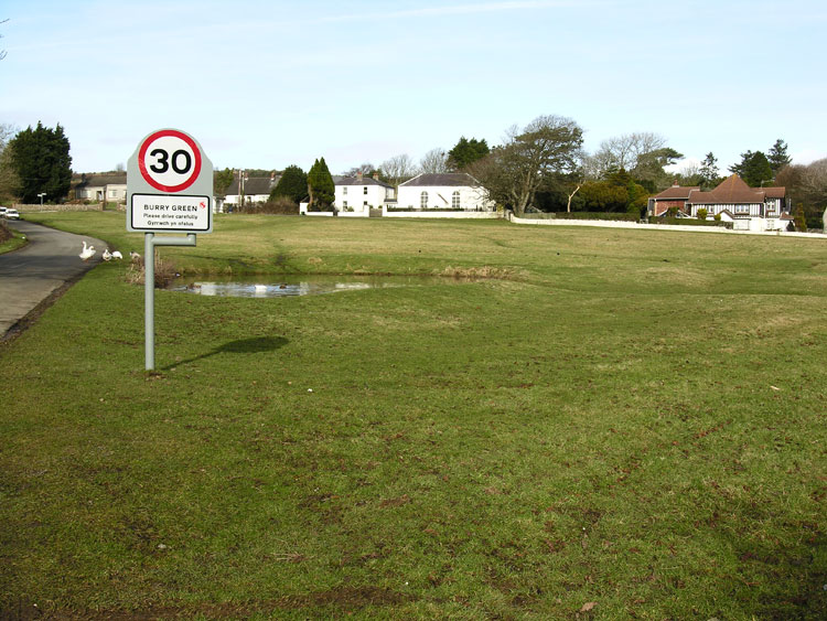
The main settlement of the area is focused around Burry Green, an open triangular area of grass with a pond, situated at the cross roads of the main routes running through the area. The settlement comprises of late post-medieval development, however, the land around the green was leased by the aforementioned Gordon family from the seventeenth century. A number of cottages and Bethesda Chapel (01485w, 9623, LB 22875 II) are shown on the first Edition OS map. The chapel was constructed with the financial help of Lady Diana Barham by the Calvinistic Society and opened in 1814. In 1823 William Griffiths was appointed as the Calvinistic Methodist minister at Burry Green, this location thereafter became the centre of Calvinistic Methodism in Gower and Griffiths himself became known as the 'Apostle of Gower', serving here until he died in 1861.
It is likely that rural crafts and industry has a long history in the area with milling dating back to the medieval period if not before. Manorial holdings during the medieval period would usually have included at least one mill. A number of mills are situated along Burry Pill/stream and mill races branch off at various points. Only one mill is included in this area although it was part of a complex of mills and associated features. Middle Mill (01562w), a water corn grist mill is first mentioned in the Margam Manuscripts in 1687 when leased to Richard Else, however, it is likely that this was the site of an earlier mill. The mill was subsequently leased by George Evans from 1759 and William Thomas in 1793. The mill then stayed with the Thomas family until 1942 when it closed due to wartime restrictions (Taylor 1991).
Settlement in the area is still limited with the addition of a number of modern dwellings along the road near Burry Green.