Blaenavon
HLCA 008 Garn-yr-Erw Transport Corridor
HLCA 008 Garn-yr-Erw Transport Corridor
Transport corridor with industrial and public railways, tramroad network, tracks and lanes. Scatter of isolated industrial rows and cottages, with a church and school, at Garn-yr-Erw. Remnant post-medieval agricultural landscape and minor industrial extraction.Back to map
Historic Background
The historic landscape area of Garn-yr-Erw Transport Corridor is bounded by the line of the Pontypool and Blaenavon Railway between Waunavon and Forgeside to the south-west and the route of the B4248 to the north-east, including the extent of enclosed land at Garn-yr-Erw.
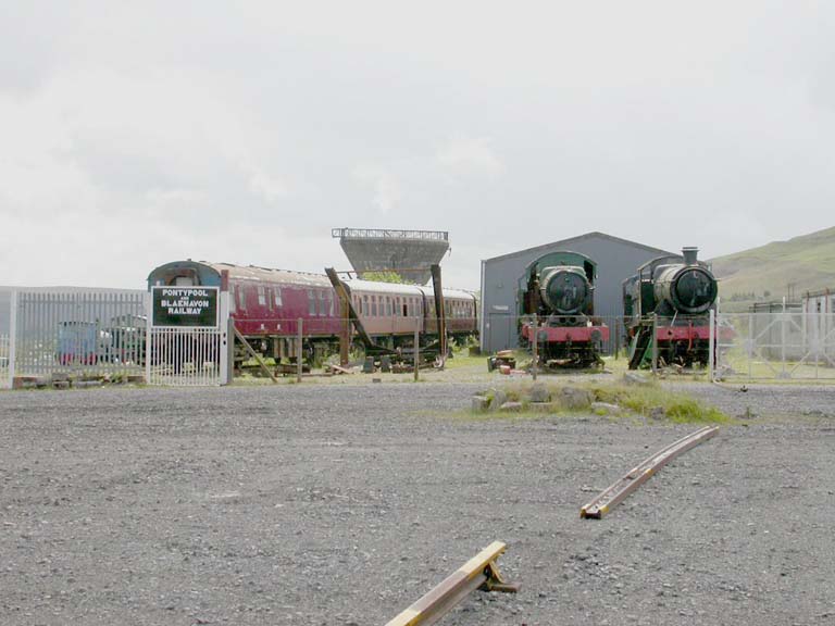
A number of interrelated transport features traversed the area, the earliest of which include tracks associated with the enclosed land and providing access to the open upland landscape to the east. By the 19th century tramways had been developed; including a route between the Blaenavon Ironworks and Garn Pits along the east side of the area and another to the west of the area which ran from Forgeside works to Garn Pits. The major transport feature associated with the area is the Pontypool and Blaenavon Railway. This opened as the LNWR Blaenavon-Brynmawr branch in 1868 to serve the ironworks, mines and collieries and was linked to Garn Pits via the tramroad to the west of the area. This line carried passengers and freight until its closure in the mid 20th century. It has subsequently been rejuvenated as a tourist attraction.
Garn-yr-Erw Farm, lease-land in the 18th century, probably represents early post-medieval encroachment onto the upland mountain common. Industrial settlement developed in this area from the mid 19th century with the construction of terraced workers' housing and cottages at Upper Garn Terrace (Mount Pleasant Terrace or Society Houses), Lower Garn Terrace, Upper Rank, Cinder Pit Cottages and Pwrcas Cottages. A chapel, Horeb Baptist Chapel, was built in 1866 and remained in use until 1905; now demolished, this was sited at the northern end of Lower Garn Terrace. By the turn of the century the settlement had gained St John's Church and the terraces of Fairmont and Fairview (also known as Black Ranks or Sheepshead Row). The settlement at Garn-yr-Erw, which also boasted a co-op shop, post office and Welfare Hall, one of the first in South Wales erected under the Old Miners' Welfare scheme, is now much reduced in size; the main elements to survive are Upper Garn Terrace, Lower Garn Terrace, Cinder Pit Cottages and Pwrcas Cottages. The unique rows known as the 'Black Ranks' were demolished in the 1980s, St John's Church has been converted into a dwelling, while the village school, established in 1894, closed in 1971 and is now in commercial use.
Historic Landscape Characteristics
The Pontypool and Blaenavon Railway, now partly restored in this area, is the dominant feature in the Garn-yr-Erw Transport Corridor. The railway, currently a tourist attraction, operates steam locomotives over its line and several locomotives are visible in the area of the former coal washery and sidings. The Pontypridd and Blaenavon Railway boasts the highest standard gauge railway in preservation in England and Wales and has a steeper continuous gradient than any other line.
Also characteristic of the area is industrial settlement; predominantly isolated rows, but also ribbon development. The surviving housing stock comprises industrial terraced stone built, single-fronted dwellings with a variety of treatments to the frontages. Many are rendered and painted in a variety of colours, some retaining brick stacks, though the majority of windows and doors have been replaced. Characteristic features include front gardens with wooden fences and rear yards with stone coal sheds with corrugated iron roofs and outbuildings in a variety of materials and styles. Approaching Garn-yr-Erw from Blaenavon are late 19th century detached, double-fronted stone built houses set back off the road; these are unrendered with slate roofs and brick stacks. The former St John's Church on Garn Road is in the Neo-Gothic style similar to St Peter's Church, Blaenavon.
Evolved irregular field pattern with field boundaries of dry-stone walling, stone-faced banks with and without hedges, and grassed banks with denuded hedges characterises the remnant agricultural landscape at Garn-yr-Erw. The landscape in the northwestern part of this area has remained essentially unenclosed. Minor extractive remains, mainly denoted by small waste tips, are characteristic of this area.