Historic Landscape
Characterisation
The Rhondda
032 Parc Cwm Brychinog
HLCA 032 Parc Cwm Brychinog
Upland mountain sheepwalk, limited forestation; prehistoric funerary landscape;
prehistoric settlement; early communication corridor; early medieval administrative
boundaries; medieval hunting park; relict agricultural features; documentary
and place name evidence; post-medieval industrial landscape.
Click here for character area map
(Back to map)
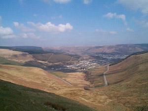
The historic landscape area of Parc Cwm Brychinog is referred to in documentary sources as being one of two medieval hunting parks within Glynrhondda, Parc Cwm Brychinog, the other lay at Rhigos north of the Rhondda Historic Landscape. The designation of the area as a Park has been preserved in the names of the farms of Parc-uchaf and Parc-isaf and of the valley itself, Cwm Parc. Parc Cwm Brychinog was divided into the farms of Parc-uchaf and Parc-isaf, Cwmdare and Bwlch-y-Clawdd during the Tudor period, necessitating the setting of new boundaries. Also of interest are the neighbouring holdings of Ystrad Ferchan and Tir Cadogan (later Tir Gibbon Dio and Pentwyn), which during the latter half of the 16th century formed part of the freehold property of the Cadwgan family, according to tradition, specifically the poems of Dafydd Benwyn a contemporary poet, a family of some local standing.
The area contains a small number of significant archaeological remains dating to the prehistoric and medieval periods. The earliest finds from the area include Mesolithic flints, including microliths and a Neolithic stone axe. Known settlement in the area dates from the prehistoric period with a flint-processing site above Cwm Parc and a possible round hut set within a circular enclosure (SAM Gm 278), near Bwlch-yr-Afan; excavation undertaken in 1962, however, indicates the latter scheduled site is in fact a post-medieval feature associated with sheep farming (SMR, PRN 0037m).
Crug-yr-Afan (SAM Gm 233), a burial cairn of the Bronze Age (2000-1000BC) is located on a highpoint overlooking the junction of three valleys at Bwlch-yr-Afan; Cwm Parc, Cwm Ogwr Fawr and Cwm Nant-ty at the head of Cwm Afan on the western edge of the area and lies on a traditional north-south boundary. The site is of an unusual type for the uplands, being a ditched barrow, similar to the bell barrows of Wessex, which date from about 2000-1450 BC. Excavation in 1902 revealed a composite mound, the lower part, comprising a clayey soil, is surrounded by a flat ledge or berm, and ditch. Cut into the subsoil beneath the mound was a central cist, containing a cremation, and a bronze dagger, grooved along it edges, of a type familiar in Early Bronze Age Wessex. A smaller stone cairn, originally surrounded by a kerb or ring of upright slabs had been raised over the lower mound. Pollen analysis from the site indicated an environment of heath and open tree cover dominated by oak.
Located at the passes of Bwlch-yr-Afan and Bwlch-y-Clawdd are the remains of banks and ditches or cross dykes, part of a more extensive system of early medieval cross dykes (8th-9th century), which control the upland ridge way routes into the Rhondda area. These features are physical reminders of the early medieval Welsh administrative landscape of the area and it is no coincidence that the cross dykes at Bwlch-yr-Afan (SAM Gm 246) and Bwlch-y-Clawdd (SAM Gm 500) lie across ancient ridge way routes, themselves date back into the prehistoric past, which traverse the boundary of the Cantref of Penychan and the Commote (and later Lordship) of Glynrhondda with the neighbouring Cantref of Gwrinydd to the west (see also HLCA 030).
The area contains a number of industrial features, principally associated with Park Colliery, including the Park Upcast Shaft. Parc Colliery was established in 1870 by David Davies and Company, and later purchased by the Ocean Coal Company Ltd. The first pithead baths in the Rhondda were installed at Parc Colliery in 1929. Six years later the colliery became part of the large Powell Dyffryn Associated Collieries Ltd and following nationalization in 1947 was amalgamated with the neighbouring Dare Colliery, eventually closing in 1966, the colliery site subsequently landscaped. Other features include coal levels and areas of partly reclaimed tips.
