Historic Landscape
Characterisation
The Rhondda
030 Rhondda Uplands
HLCA 030 Rhondda Uplands
Upland mountain sheepwalk, partially forested; multi-period and multi-functional
landscape; prehistoric settlement and funerary landscape; early communication
corridor; Roman and medieval military structures; early medieval administrative
boundaries; medieval upland settlement; post-medieval industrial landscape;
relict upland agricultural landscape; documentary and place name evidence.
Click here for character
area map
(Back to map)
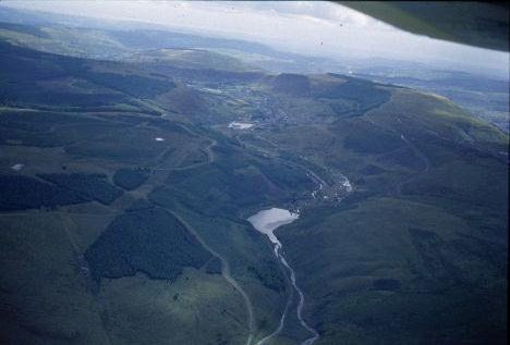
(Photo: GGAT HLCA030)
Aerial view of the Lluest-wen Reservoir and the upper reaches of the Rhondda Fach.
The historic landscape area of Rhondda Uplands is a landscape of some importance, with a variety of surviving archaeological features displaying considerable time-depth. The dominant character of the landscape is that of unimproved, common upland sheepwalk, where coarse grasses and sedge vegetation predominate, a significant proportion of which has been turned over to forestry; large plantations of spruce, fir, and occasional stands of larch. The terrain is characterised by gently sloping bare summits, bordered by craggy cliffs and steep wooded slopes. Apart from agriculture, previous land use included quarrying for building stone, notably from the disused Ynys-feio Quarry and trial prospecting for minerals, coal levels.
The area contains a number of important archaeological remains of varying periods. Numerous finds of material dating to the Mesolithic period (10000-4400BC) have been recovered throughout the area indicating considerable occupation of the higher ground during the period; the material includes assemblages and individual finds of flint, including cores, blades, flakes, scrapers and microliths often associated with charcoal from Cwm Saerbren, Mynydd Beili-glas, Mynydd Blaenrhondda, Nant Lluest, Mynydd Tyle-coch, Mynydd Ystradffernol, and the area of Maerdy Reservoir. Mesolithic settlements are known at Craigyllyn (part excavated by Lacaille in 1962) and at Mynydd Beili-glas. The Neolithic (4400-2300BC), and the Bronze Age (2300-800BC) are also well represented, again throughout the area, by finds of flint tools, including Neolithic petit tranchet and leaf shaped arrowheads and Bronze Age long-tanged, and tanged and barbed arrowheads and of considerable interest is a dated late Neolithic hut floor located at Cefn-glas.
The most visible and common prehistoric site in the area are the burial cairns of the Bronze Age. These features are numerous and include Bachgen Carreg (SAM Gm 234), Carn Fach, Carn-y-Pigwn (SAM Gm 372), Carn-y-wiwer (SAM Gm 323), Carn-y-Bica, Bedd Eiddil, Garnwen, and Pebyll among others. Settlement appears to be continuous with occupation spanning both the Iron Age and the Roman period, a good examples is the late-prehistoric/Roman (800BC-AD410) settlement site of Hen Dre'r Mynydd (SAM Gm 101), the largest undefended Iron Age settlement in south-east Wales, a site of national importance, located at SN 923 018 to the north of the area on the upper slopes of Mynydd Beili-glas. Excavations of 1921 revealed the material poverty of the occupants; little being recovered apart from a small amount of iron and evidence of leather. The 1st century Roman marching camp at Twyn-y-Briddallt (SAM Gm 259), located above Blaenllechau and Craig y Gilwern, is a well-preserved example of its type. The Roman Road, which connects the forts at Neath and Penydarren, is thought to cross the north of the area, on the line of the traditional ridge way route of Cefn-ffordd (see below).
Features of the medieval period include an extensive system of well-preserved early medieval cross dykes (8th-9th century), which guard the upland ridge way routes into the Rhondda. It is perhaps no coincidence that these cross dykes, lie across the ancient ridge way routes (which themselves date back into the prehistoric past) and also demarcate early medieval administrative boundaries between cymydau (commotes) and cantrefi (hundreds); Ffos Toncenglau (SAM Gm 118) at SN 916031 - 919020, demarcates the northern border with Cantref Mawr, straddling the ancient ridge way route of Y Gefn-Ffordd (Heol Adam) and that (SAM Gm 285) near Bedd Eiddil at Bryn-du, also straddles Y Gefn-Ffordd, at Twyn Croesffordd, where its route crosses the eastern border of Glynrhondda with the cwmwd (commote) of Meisgyn (Miskin). Also of note is the medieval castle site of Castell Nos (SAM Gm 408) north of Maerdy, situated on a rocky outcrop overlooking Cwm Rhondda-fach. The sites defences comprise a man-made escarpment and ditch on the north and west sides. The Royal Commission suggest it was a stronghold of Maredudd ap Caradog ab Iestyn, the Welsh ruler of Meisgyn during the late 12th century. A well-preserved example of medieval upland settlement is to be found at Carn-y-wiwer, comprising two groups of typically paired house platforms (SAM Gm 323). To the north and east of the platform houses is a group of c. 19 small cairns associated with evidence of ploughing; the relationship between the different elements of this landscape is, however, as yet unestablished; the cairns may be Bronze Age burial cairns, the ploughing may be latter than the house platforms, or they could all be contemporary, with the cairns representing clearance material from the adjacent fields. Other medieval settlement sites in the area include a group of four house platforms on Craig Tir Llaethdy, a long hut and a platform hut at Cwm Saerbren, while further platform houses are located at Graig Rhondda-fach and on Mynydd Ty'n-tyle. Enclosures or pounds of the period remain at Ffald Lluest and Tarren Saerbren.
The platform houses, such as those at Carn-y-wiwer, overlooking the Rhondda Fach valley and other remains of hafodau and lluest sites throughout the area recall exploitation of the uplands, often on a seasonal basis, for cattle, and later sheep, farming during the medieval and post-medieval periods; this is also born out by place-name evidence and cartographical evidence. Pont Lluest-wen, an early 19th century single-arched (segmental headed), single-track bridge over the Afon Rhondda Fach lies near the border of the area.
Industrial features include Ynys-feio Quarry, the Abergorky Quarry and a flagstone quarry at Bryn-y-gelli-uchaf (Dunraven estate papers). Minor quarrying is noted particularly from the publication of the 2nd edition OS map of 1900, as are the extensive workings of the National Colliery, Wattstown with its tramway/incline, by the 3rd edition quarries and a further substantial linear tramway/incline are in place above Ynyshir extending into the area. Extensive coal tipping has also occurred along the ridge above Maerdy.