Historic Landscape
Characterisation
The Rhondda
028 Mynydd Dinas and Mynydd Cymmer
HLCA 028 Mynydd Dinas and Mynydd Cymmer
Mountain or upland sheepwalk; relict agricultural features; prehistoric
funerary use; post-medieval settlement, agricultural and industrial; extensive
upland industrial landscape.
Click here for character
area map
(Back to map)
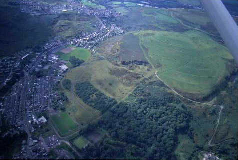
(Photo: GGAT HLCA028)
Aerial view of Mynydd Dinas showing remnant woodland and partly reclaimed/landscaped summit.
The historic landscape area of Mynydd Dinas and Mynydd Cymmer is chiefly open mountain and combines prehistoric funerary use with medieval and post-medieval agricultural and later industrial exploitation. The earliest archaeological feature known in the area is a single burial cairn dating to the Bronze Age (2,300-800BC), on Mynydd Dinas. The name of Mynydd Dinas suggests the location of an Iron Age or early medieval defensive encampment or settlement in the area, although none is known. The agricultural use has been stock grazing, latterly sheep, mostly carried out from farms located in the low lying areas outside the HLCA; the first edition OS 6" map of 1884 provides evidence of sheep folds and shelters. The only farmstead located within the area is Craig-ddu Farm, a two-unit, one and half storey downhill-sited post-medieval farmhouse.
The most extensive area of industrial features was on Mynydd Cymmer. In addition to the usual disused quarries, coal levels, airshafts and tramways/inclines, depicted on 2nd edition (1900) and 1921 edition OS 6" maps, the area contains, at Penygefnen, Dinas, an interesting example of early industrial housing (1840-1879), the remains of a square plan terrace of three one-up one-down cottages (Fisk 1995).