Historic Landscape
Characterisation
The Rhondda
024 Rhondda Fach:
Western Enclosed Valley Sides
HLCA 024 Rhondda Fach
Prehistoric funerary landscape; relict agricultural landscape to an extent
modified by industrial development; distinctive field boundaries; documentary
evidence of medieval/post-medieval agricultural practice and settlement;
medieval upland settlement; post-medieval upland farmsteads (longhouses);
industrial landscape associated with mineral extraction, predominantly
coal; ancient woodland and modern forestation.
Click here for character
area map
(Back to map)
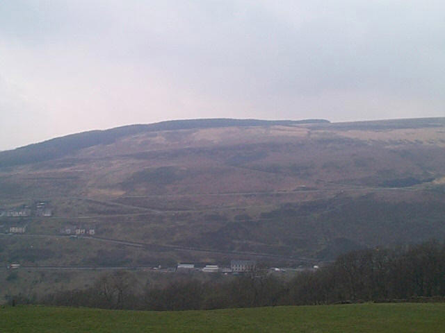
(Photo: GGAT HLCA024)
Enclosed slopes of Mynydd Ty'n Tyle, viw from the east.
The historic landscape area of Rhondda Fach: Western Enclosed Valley Sides contains features and finds dating to the Bronze Age (2300-800BC), typically funerary monuments, such as the round barrow/cairn(s) on Tarren Maerdy and a find of a bronze axe nearby. A number of medieval settlement features are also preserved in the area, such as the characteristic platform house sites of Twyn Disgwylfa and Craig Rhondda-fach. The Tithe map (Ystradyfodwg 1844) presents a number of Coedcae field names, indicating extensive post-medieval woodland clearance, or at least the enclosure and use of the woodland margins during this period.
The 1st edition 6-inch OS map (1884, surveyed 1875) shows the area with no industrial development, and largely unchanged from the earlier Tithe map of Ystradyfodwg Parish (1844). During the period the landscape is characterised by a mixture of rough, mountain pasture with the lower, steeper slopes to the southeast of the area densely covered by scrub woodland. The two main wooded areas are Coed Cynllwyn (above the area later developed as Tylorstown), Coed Maerdy, and Coed Rhondda-fach (above Llyn y Forwyn, Ferndale). Parcels of enclosed improved pasture centred around Maerdy, Rhondda Fach and Dyffryn (Sarfwch) farms belonged to various estates, and mostly comprised small and medium sized irregular fields; these now generally lie outside the current HLCA, having been subsumed by late 19th century urban and industrial development.
The predominant industrial features of the area are quarries; depicted on the 2nd edition OS map of 1900; these were associated with the construction of the nearby industrial settlements of Ferndale, Maerdy and Tylorstown.