Historic Landscape
Characterisation
The Rhondda
018 Wattstown
HLCA 018 Wattstown
Compact 2nd phase pithead settlement associated with a single colliery;
planned, compact settlement of linear terraces, with later 3rd phase additions
including hillside estate; predominant colliery constructed housing -
good examples of post-legislation colliery housing; residential colliery
settlement with limited functional/morphological variety; historic associations.
Click here for character
area map
(Back to map)
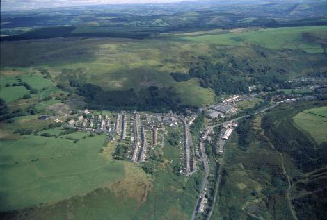
(Photo: GGAT HLCA018)
Aerial view of Wattstown from the west.
The historic landscape area of Wattstown developed north of the Afon Rhondda Fach on the farm land of Aberlleche and Tirbach (held by the executors of Anne Saunderson on the tithe of Llanwonno 1841). The first edition 6-inch OS plan surveyed 1875 shows only the Butchers Arms public house and Aberllechau farm at Pont-rhyd-y-cwch, later known as Wattstown, and no development. Crawshay and William Partridge Bailey obtained the mineral rights for Pont-rhyd-y-cwch in 1881. During the same year Ebenezer Lewis, Henry Lewis and Mathew Cope formed the United National Coal Company, and sank the Nos. 1 and 2 shafts (also known as Pwll Mawr and Pwll Bach) to work the six-foot seam. These shafts later worked by other companies including as Messers Griffiths and Company and Messers Watts and Company. The National Colliery (locally known as the Cwtch Colliery) was the location of an explosion in 1887, which claimed the lives of 39 men. Under the National Steam Coal Company (later the National Collieries Company Ltd.) the shafts were deepened in 1894 to work the lower five-foot steam coal seams. In 1905, another explosion occurred, this time 119 men and boys lost their lives, the worst mining disaster in the valleys since Ferndale in 1867. In 1914 the colliery was amalgamated with Standard Collieries, and later became part of the Ocean Coal Company. Geological problems caused output to fall following nationalization and the colliery was closed in 1968 (Carpenter 2000).
The pithead settlement of Wattstown originated during the 1880s, following the establishment of what became the National Colliery. The settlement climbs the valley side in a series of linear terraces, contouring the slopes above the Taff Vale Railway (Rhondda Fach Branch) constructed in 1856 and the National Colliery, which effectively take up the restricted space of the valley floor. The lower part of the settlement north of the Afon Rhondda Fach at Pont-rhyd-y-cwch comprised Aberllechau Road with its chapel, post office and two public houses, while on the opposite side of the river was the goods station. The 2nd edition OS map depicts St Thomas's Church and a chapel immediately above the National Colliery, while contouring the lower slopes to either side of Nant Llechau and the National Colliery are the main residential areas of Hillside Terrace and Bailey Street. The National Steam Coal Company obtained leases to construct houses for its colliers in the area: for 60 houses at Hillside Terrace in 1884 and in 1885 for a further 39 houses in Hillside Terrace and Bailey Street. These were all of a single fronted design with a reversed stair from living room giving access to 3 upstairs' bedrooms off a small landing area and a rear scullery extension (Fisk 1995). At this stage in the development of the settlement construction has begun to rise further up the slopes on the west side of Nant Llechau to include Victoria Street, Stanley Street with its school (later School Terrace), Bryn Terrace and the eastern end of Pleasant View (2nd edition 6-inch OS map of 1901, revised 1898). The local colliery company, then the United National Collieries, was also instrumental in the construction of Pleasant View, where 40 houses were built. Development continues, but at a slower pace, with the extension of Pleasant View to its full length and the preparation of the street layout for a further terrace above (1921 edition 6-inch OS map, revised 1914-15). New Bryn Terrace, Heol Llechau, Heol Ceiriog, Heol Goronwy and Heol-y-Twyn are later, and include council housing developments.