Historic Landscape
Characterisation
The Rhondda
017 Ynyshir
HLCA 017 Ynyshir
First colliery settlement in the Rhondda Fach valley; 1st, 2nd and 3rd
phase colliery settlement, originating as typical isolated rows during
1st phase, but present character dominated by late 19th and early 20th
century expansion and linear-layout, development strongly associated with
fortunes of associated collieries; predominantly residential in character,
mostly post-1870s housing stock; minor commercial development
Click here for character
area map
(Back to map)
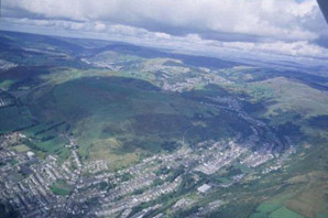
The historic landscape area of Ynyshir comprises the earliest colliery settlement of the Rhondda Fach Valley. The initial settlement was constructed on the west bank of the Afon Rhondda Fach on the low-lying meadows and woodland of Ynyshir farm, then in the ownership of Edward Williams (Tithe map of Ystradyfodwg 1844), later expanding east of the river and the land of Maendy and Pen-rhiw farms (part of the estate of Rev. George Thomas, Tithe map of Llanwonno 1841). The settlement evolved initially as a loose scatter of isolated rows based on the earliest major mining venture in the area, the Ynyshir Colliery, sunk in 1845 by Messers Shepard and Evans, trading as the Ynyshir Coal Company. Purchased by Francis Crawshay in 1856 it was extended to supply his Treforest Tin Works, it was later sold to Thomas Jones of Maendy House, Ynyshir in 1873 and under the name of Jones Navigational Colliery it was deepened to work the No. 2 Rhondda seam (the colliery eventually closed due to unprofitably in 1909). By 1875 the settlement comprised a number of cottages, later to become Wind Street, to the southwest of the colliery and its coke ovens, and Danygraig House. At the site of the Standard Colliery sunk in 1874 by William James Thomas and Daniel Thomas of Dinas, were two shafts an air and coal shaft and a tramway connection to the Taff Vale Railway, while to the south an isolated row appears to be under construction. Other features include a millrace and limekiln (1st edition 6-inch OS map of 1884, surveyed in 1875).
This initial settlement was superseded by the rapid development of the area by the end of the 19th century; the success of the Ynyshir and the Standard collieries being the main reason and by 1898 the majority of Ynyshir west of the river, is in place, complete with its linear grid pattern imposed on the unplanned scatter of the earlier settlement. At this date the settlement extended from James Terrace and the Eagle Hotel in the south, the Taff Vale Railway to the east, Gaynor Place and Grey Road in the west, as far north as the Standard Colliery, Incline Row and Danygraig Terrace; the area contains the usual plethora of non-conformist chapels, including Bethany Chapel, (an early chapel of the long-wall façade type), and Moriah Calvinistic Methodist Chapel (remodelled in 1909-1910 by RS Griffiths) both on Ynyshir Road, as well as schools and a public house. Adjacent to the Standard is Brynawel House, built by WJ Thomas, from where he oversaw the day-to-day management of his colliery. East of the Taff Vale Railway near Maendy House, St Anne's Church (1885-6 EM Bruce Vaughan in the Early English style), and Ynyshir station are evident, while east of the river a number of cottages are in place on the Llanwonno Road (2nd edition 6-inch OS map of 1901, revised 1898). Thereafter the greatest development occurs east of the Taff Vale Railway to the river and beyond; Church Terrace, Cross Street, John Street, Standard Terrace, Station Street, William Street and Ynys Street have been constructed west of the river, while the long terraces of Standard View and Heath Terrace contour the hillside to the east. To the west expansion is less dramatic, but equally dictated by the steep gradient of the available land (i.e. as at Gaynor Avenue and Upper Gaynor Place) and includes a large school on Haig Road (1921 edition 6-inch OS map, revised 1914-15). The Ynyshir Miners' Hall dates to this period, built 1905-6 to designs of E Williams, Cardiff, remodelled c. 1930. The other notable changes are the opening of the Lady Lewis Colliery in 1904 under the ownership of Lewis Merthyr Consolidated Collieries Ltd and the closure of Ynyshir Colliery in 1909; the former is rapidly developed and by 1913 employed 1,228 men (Carpenter 2000).
