Historic Landscape
Characterisation
The Rhondda
014 Ty-newydd
HLCA 014 Ty-newydd
Planned colliery-built terraced settlement, originally conceived as a
Model Village; 1st phase colliery settlement with 2nd and 3rd phase additions,
relatively low level of commercial development; typical terraced housing
and converted commercial properties; site of Rhondda Merthyr Colliery
(tips extant).
Click here for character
area map
(Back to map)
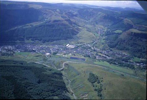
(Photo: GGAT HLCA014)
Aerial view of Ty-newydd with Cwmparc in the background.
The historic landscape area of Ty-newydd comprises a colliery settlement erected on the Bute estate property of Ty-newydd, and the neighbouring property of Ystradffernol, part of the Dunraven estate. Ty-newydd Farm, a rare vernacular survivor in the Rhondda, is a 17th century three-unit, chimney-backing-on-entry house with storied porch and hall between outer and inner rooms, both heated (hearth-passage group: houses with hall outer and inner rooms, or type B porch-entry house), with a sundial dated 1652. The settlement later erected nearby was a scaled-down substitute for the proposed Model Village of Bryn Wyndham, originally conceived by the industrial philanthropist Thomas Joseph for Clyngwyn in the neighbouring area of Blaenrhondda. It is suggested that Thomas Joseph, who had opened colliery levels at nearby Blaenycwm during the late 1850s and 1860s, drew inspiration from the work of Welsh philanthropist Robert Owen at New Lanark in Scotland. More likely influences, however, are the work of Benjamin Hall at Abercarn, and that of ironworks manager Richard Johnson at Butetown (Fisk 1996). The core of the settlement of Ty-newydd comprised 20 or so houses on Scott's Street and Wyndham Street, with a further 60 dwellings built after 1872 by the London & South Wales Coal Company to whom Thomas Joseph sold his interests. The housing, and the development itself, was carried out to a far lesser specification than that originally planned for the Model Village.
The 1st edition 6-inch OS map of 1884, surveyed in 1875, names the village of Bryn Wyndham, whereas the area is renamed Ty-newydd by the publication of the 2nd edition 6-inch OS map in 1900. The 1st edition shows the linear terraced plan of the original settlement core, which included Wyndham Street, Scott's Street and Bull's Row with the Wyndham Arms (Public House) and chapels. The collieries of Ty-newydd and Rhondda Merthyr are both depicted, as is the Taff Vale Railway, opened in 1856. Other housing is under construction, i.e. Blaenycwm and Bryn Wyndham Terraces and Gwendoline Street. By the publication of the 2nd edition (1897-98, published 1900) the above development is completed with the addition of a school and Halifax Terrace and the area to the south of Ty-newydd house (i.e. Miskin Street) is being developed, while the Rhondda & Swansea Bay Railway, opened in 1890, now serves the area in addition to the Taff Vale Railway. The Ty'n-y-waun Reservoir has also been built by this period. The settlement reached its optimum just prior to the First World War with additional housing southwest of Halifax Terrace, south of Ty-newydd House, and in the area between the two railway lines (1921 edition 6-inch OS map, revised 1914).