Historic Landscape
Characterisation
The Rhondda
012 Cwmparc
HLCA 012 Cwmparc
Example of pithead colliery settlement(s), which evolved from isolated
rows during the 1st phase, unified into a single continuous linear settlement
during the 2nd and 3rd phases; linear terraces, giving the area a uniform
visual aspect; residential colliery specific settlements with limited
functional/morphological variety; examples of pre-1880s colliery housing
and later speculative housing; reclaimed colliery landscape; separate
tributary side-valley location.
Click here for character area map
(Back to map)
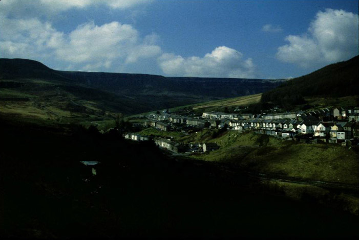
(Photo: GGAT HLCA012)
Cwmparc, view from east with Graig-fawr in the background.
The historic landscape area of Cwmparc is associated with the development of the Parc & Dare collieries. Dare colliery sunk in 1865 and Park Colliery in 1870, were both established by David Davies and Company, and later purchased by the Ocean Coal Company Ltd. In 1929 the first pithead baths in the Rhondda were installed at Parc Colliery. In 1935 both became part of the large Powell Dyffryn Associated Collieries Ltd and following nationalization in 1947 were amalgamated and eventually closed in 1966 under the NCB. Both colliery sites were subsequently landscaped; a Community Hall and housing now stands on the Dare colliery site.
The settlement was erected on the property of Griffith Llewellyn and Leyshon Morgan at Cwmdare, Parc-isaf, and Parc-uchaf farms, and later extended to include the lower lying areas of Pencelli and Ystrad-fechan farms. The underlying way in which the settlement develops can be followed from the cartographic evidence. This starts with the sinking of the initial colliery and adjacent (slightly haphazard) colliery built pithead settlement, closely followed by further expansion in the form of secondary pit sinking with more regular planned colliery pithead settlement, and linking infrastructure. Soon after a spate of non-conformist chapel building in the vacant area between the two pithead settlements follows and only then further speculative housing, eventually linking the two pithead areas into one single large linear settlement. While chapels were generally built by public subscription, the earliest housing stock of the area appears to have been largely built by the local colliery company. David Davies's Ocean Coal Company continued to construct housing in the area until c. 1875; the two storey single-fronted terraced house was typical of these properties (Fisk 1995).
Initial development, between 1866 and 1875, was in the areas immediately adjacent to the colliery sites; the earlier core apparently northeast of the Dare Colliery comprising the eastern end of what later became Baglan Street and Lower Terrace with a Hotel erected nearby, while a more regularly laid out linear group of terraces had been constructed to the north and east of Park Colliery, essentially Greenfield Row and Cwmparc Row (later renamed Railway Terrace) with its Independent Chapel, and the Tremain Inn public house. Both Rows were at the time connected by tramway to the Park Colliery. Both collieries are served by the Cwmparc Railway, which links with the Rhondda branch of the Taff Vale Railway. The two pithead settlements of the time were linked by the forerunner to Parc Road, along the north side of which had been constructed a school, Bethel Chapel (Baptist), Park Chapel (Calvinistic Methodist) and opposite a Reading Room; this area is as yet undeveloped for housing (1st edition 6-inch OS map 1884, surveyed 1875).
By the end of the 19th century the core of the settlement of Cwmparc is in place, including Cwmparc Road, Baglan and Tallis streets. Houses and a Post Office have taken the formerly unoccupied plots along Cwmparc Road and a church a late addition to the religious landscape of the area, (St George's by GE Halliday 1895-6, the Arts and Crafts Perpendicular style) has been built on Tallis Street, upslope and behind the main Baglan Street. To the east away from the main settlement Pencae Terrace with the attached Pengelli Hotel have been built north of Ystrad-fechan farm (2nd edition 6-inch OS map 1900, revised 1897-98). During the post-1875 period housing in the area is almost exclusively built for property investors as speculative ventures. By 1914 the linear terraced form of Cwmparc is more or less complete; additions to the settlement include houses along the south side of Cwmparc Road (now known as Park Road), and terraces constructed parallel to this, Barrett, Castle and Treharne Streets and Vicarage Terrace. The area above Pencae Terrace at the northeast of the settlement has also been developed to include Conway Road, Chepstow and Clifton Streets, the latter two streets being exclusively houses built for building-clubs of colliery workers, while allotment gardens near the two collieries and additional schools have also been constructed by this date (1921 edition 6-inch OS map, revised 1914).