Historic Landscape
Characterisation
The Rhondda
011 Treorchy
HLCA 011 Treorchy
Significant commercial and service centre; 1st phase settlement mostly
on Bute Estate land with visibly high degree of planning, comprising generously
laid out main street, later developed as the commercial core with flanking
linear-grid layout established over all three phases; significant commercial
centre developed from initial colliery settlements; characteristic built
features, mostly late 19th/early 20th century, include terraced housing,
chapels, churches, public buildings, shops and workmen's institutes; large
cemetery serving surrounding area, i.e. the Rhondda Fawr; settlement associated
with number of local collieries, but primarily the Abergorki Colliery
with its outlying settlement of isolated rows; major road junction; cultural
associations.
Click here for character
map
(Back to map)
(Photo: GGAT HLCA011)
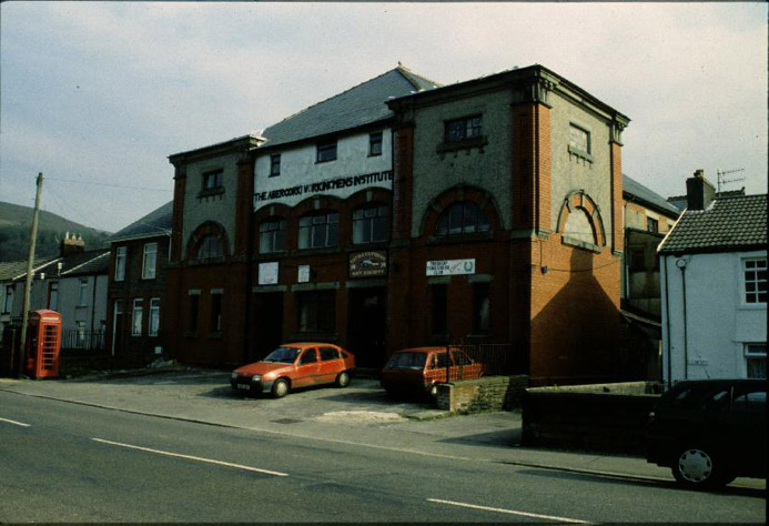
Treorchy: The Abergorgki Workingmens' Institute.
The historic landscape area of Treorchy includes the adjacent settlement of Ty'n-y-bedw to the southeast. The area contained the most extensive area of demesne land in the medieval Lordship of Glynrhondda, comprising the holdings of Ystrad Ferchan and Tir Cadogan (later Tir Gibbon Dio and Pentwyn), which during the latter half of the 16th century formed part of the freehold property of the Cadwgan family, according to tradition, specifically the poems of Dafydd Benwyn a contemporary poet, a family of some local standing. The modern settlement of Treorchy itself was established entirely on lands of the Bute estate from the 1850s, (including the farms of Tyr Gibbon, Ystrad Fechan, Tyr y Felin, Glyn Coli, Tile Du and Abergorchwy), the spacious layout of the roads reflecting the control the estate exerted on planning (after the Public Health Act of 1848). The area of Ty'n-y-bedw was developed on Crawshay Bailey land adjacent to Pentre takes its name from the farm of the same name. The principle cause of Treorchy's growth was the Abergorki Colliery situated in Cwm Orci to the north, opened as a level in 1859 by Haughty Huxham, a former manager of the Bute Merthyr Colliery and sold to JH Insole of Cymmer in 1862, eventually closing in 1938. Other collieries linked to urban development of the area are the Parc & Dare collieries (outside the HLCA itself), sunk in 1865 and 1870 by David Davies and Company, both closed in 1966 under the NCB; Tyle-coch Colliery, sunk 1854 by the Newcastle firm of Messrs. John Carr, Morrison and Company and closed in 1895, a Secondary Modern school erected on the site in 1965; and Ty'n-y-bedw Colliery, sunk in 1876 by Edmund Thomas and George Griffiths and closed in 1933.
The initial development appears to have been ribbon development along the main thoroughfare producing Bute Street and High Street, as mentioned before the street layout is wide and spacious, by the survey of the 1st edition 6-inch OS in 1875 an embryonic linear grid-pattern is emerging to the southwest and northeast of the main thoroughfare, including Cardiff Street, Chapel Street, Clark Street, Dumfries Street, Herbert Street, Luton Street (with the Parc & Dare Band room, home of the famous colliery band), River Row, School Street, Senghenydd Street, and Windsor Street. The long terraces of two-storey cottages, which line either side of High Street, are largely erected by this time, however Ty'n-y-bedw has yet to develop beyond this initial main ribbon. By the period the town has a church, St Mathew, by George E Robinson 1871, with its associated church school. Also evident are at least four non-conformist chapels, mostly located on the main street: Capel Bethlehem (Calvinistic Methodists, later remodelled in 1881); Capel Noddfa (Welsh Baptists); Horeb Chapel; and Tabernacle Chapel (Welsh Independents). The town also has gained its substantial and characteristic cemetary with two mortuary chapels, one Church of England and the other Non-conformist. The only named hostelry is the Red Lion Inn at the Ty'n-y-bedw end of the town. The only development southwest of the river Rhondda at this date is Tyle-coch Place, northwest of Tyle-coch Colliery and Taff Terrace immediately southwest of the Taff Vale Railway and Treorchy Station itself. Also depicted are the town's brickworks, Ty'n-y-bedw quarry, Tyle-coch and the Abergorki Collieries, each with their respective tramways, the latter with its own fragmented pithead settlement of isolated rows, Upper and Lower Rows (now demolished), and the coal shafts near Myrtlehill, later Ty'n-y-bedw Colliery (1st edition 6-inch OS map 1884, surveyed 1875).
By 1897-98 Treorchy's linear grid pattern is well established, Dumfries Street has been extended and the street layout southwest of Bute Street to the Afon Rhondda Fawr is complete. The linear grid layout at Ty'n-y-bedw is in place to either side of High Street, including Regent Street, Ty'n-y-bedw Street, and Prospect Place. Treorchy has a Post Office, additional chapels and an infant school by this period, while southwest of the river a Methodist Chapel and Workmen's Institute (The Parc & Dare Workmen's Hall, by Jacob Rees 1895, and the magnificent classical façade of 1913) have been constructed (2nd edition 6-inch OS map 1900, revised 1897-98). Urban development continues up to the outbreak of World War One, mostly in the form of vertical expansion up the valley sides, including Stuart and Treasure Streets, Troed-y-rhiw and Ty'n-y-bedw Terraces, while southwest of the river Dyfodwg and Illtyd Streets have been built. The Police Station, Pavilion and Congregational Chapel, southwest of the river date to the period (1921 edition 6-inch OS map, revised 1914). Belonging to this period is the Crown Hotel, High Street, in Arts and Crafts Baroque style, built c. 1910.