Historic Landscape
Characterisation
The Rhondda
010 Ton Pentre and Gelli
HLCA 010 Ton Pentre and Gelli
Composite colliery settlement comprising: mid-19th century 1st phase 'pithead'
development with initial colliery built housing and grid-layout taking
pre-existing road system into account and adjacent isolated rows; and
later19th century 2nd phase expansion on linear grid layout, including
creation of a large 2nd phase 'pithead' settlement at Gelli and minor
3rd phase additions; residential colliery village with low urban morphological
and functional development; medieval and later parochial centre (Ton Pentre).
Click here for character
area map
(Back to map)
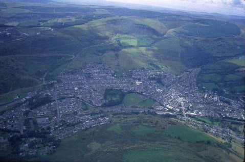
(Photo: GGAT HLCA010)
Aerial view showing Gelli, centre, and Ton Pentre, right.
The historic landscape area of Ton Pentre and Gelli comprises two 'pithead' settlements on the west bank of the Afon Rhondda Fawr, the earlier Ton Pentre appears to have originated during the 1860s, centred on the parish church of Ystradyfodwg, which had been rebuilt 1846 on the site of the original medieval building. Gelli, on the other hand, is primarily a later, 2nd phase colliery settlement, dating from the late 1870s. The area was held by the estate of Crawshay Bailey and included the post-medieval farms of Gelli Fawr, Maendy, Ton, Ty-isaf, Tyr yr Eglwys, and Ynyscoy; many of which probably had medieval precursors. A small portion of the neighbouring farmland of Penpont Rhondda is included at the southern margin of the area (Tithe plan and apportionment for Ystradyfodwg, 1844).
The area's collieries include Maendy Pit and Gelli Colliery, and slightly further afield are Eastern Pit, Bwllfa Level and Ton Colliery located in the neighbouring area to the southwest. Maendy Pit (or Ocean Colliery), sunk after 1864 by David Davies of Llandinam, struck the rich 4ft steam coal seam in 1866. Davies marketed this coal as Ocean Merthyr coal, using the well-known name of Merthyr as a selling point. At its peak in 1894 the colliery was employing 1,399 men; this figure was down to approximately 350 when it closed in 1948 under the National Coal Board. The site was subsequently cleared and landscaped; an executive housing estate was eventually constructed on the site during the early 1990s. Gelli Colliery was sunk in 1877 by Edmond Thomas and George Griffiths and bought in 1884 by Cory Brothers of Cardiff a year after a gas explosion had lead to the deaths of five miners. At its peak in 1928, under the ownership of the Powell Dyffryn Company the colliery was producing 950 tons of best quality steam coal per day with a workforce of 1,200 miners. The site was cleared in 1964 and subsequently developed as an industrial estate. The tramways connecting the Bwllfa Levels, Maendy Pit, Ton Colliery and Eastern Pit to the Taff Vale Railway, depicted on the 1st edition OS map were prominent features of the landscape (1st edition 6-inch OS map 1884, surveyed 1875). The development of the area was no doubt encouraged by the construction of the Taff Vale Railway in the 1850s, which had commenced passenger services by 1861.
By 1875 the village of Ton (Pentre) is depicted as a grid plan immediately south of the parish church of St. John the Baptist and its vicarage (earlier dedicated to the Celtic Saint Tyfodwg). The village comprises Church Road, church Street, Llanfoist Street, Parry Street and north of and adjacent to the Maendy tramway, Ton Row. In 1865 the local colliery proprietor David Davies of Llandinam and his partners built the lower part of Ton Row, Ton Pentre. With the success of his Ocean Colliery, Davies went on to develop much of Ton Pentre, including the upper part of Ton Row and Parry Street, his concern eventually owned several hundred houses in the area. Characteristic of the Ton Row development is the local stone single-fronted two-down with pantry, three-up terraced house with timber curved stair with brick used in the chimney and flue. During the period, apart from the earlier medieval church, the area gained two chapels, Capel Hebron and Jerusalem Chapel (Calvinistic Methodist, built 1881 in the classical style by the Rev. William Jones), two Hotels the Gelli Hotel and the Windsor Castle. The 1st edition OS map depicts Gelli Colliery with its coke ovens, Gelli Row, and a brewery, Gelli Brewery (1st edition 6-inch OS map 1884, surveyed 1875). Within twenty years the 2nd phase pithead colliery settlement of Gelli had been constructed to a grid layout in the area southwest of Ystrad and the Afon Rhondda; Alexander Road, Avondale Road, Dorothy Street, Lloyd Street, Stanley Road and Ystrad Terrace and the church of St David all belong to this phase (2nd edition 6-inch OS map 1900, revised 1897-98).
During the same period Ton Pentre expanded north and west in grid fashion unto Nant Iain, with the extension of Parry Street and Ton Row west of Church Road and the creation of additional terraced streets, including among others Bailey Street, Canning Street, Clara Street, Gordon Street, Metexta Street, Queen Street. Much of the housing development during this phase was carried out for building-clubs of colliery workers, the remainder being carried out as speculative ventures for property investors (Fisk 1996, Jones 1969). The Gothic English Congregational Chapel (1884) on Church Road also dates to the period, as does the imposing Bethesda Welsh Independent Chapel on Bailey Street, remodelled in 1906-07 in the classical style by WD Morgan. The church of St John, since replaced by a modern edifice, was also rebuilt between 1893-4 to the designs of Bruce Vaughan (Newman 1995). Settlement growth continued, by 1914 additional houses had been erected further up the hillside, including Belgrave Street, Kennard Street and Wyndham Street in Ton Pentre, while in Gelli a similar pattern of linear hill side terraces is repeated, including Bronllwyn Road, Colwyn Road, King Street, Llanfair Hill and South Street. Notable changes to the urban landscape at both Gelli and Ton Pentre were additional schools, a drill hall (Ton Pentre) and the generous provision of allotment gardens, most located adjacent to the tramways leading to the collieries (1921 edition 6-inch OS map, revised 1914).