Historic Landscape
Characterisation
The Rhondda
007 Cwm Clydach
HLCA 007 Cwm Clydach
Example of fragmented 1st phase pithead colliery settlements, comprising
isolated terraced rows; later, 2nd phase planned settlement with distinctive
grid-layout street pattern, and linear terraces, with later 3rd phase
hillside accretions, giving the area a largely uniform visual aspect;
residential colliery settlements with limited functional/morphological
variety; examples of post 1870s building-club and speculative housing;
reclaimed colliery landscape; separate tributary side-valley location.
Click here for character
area map
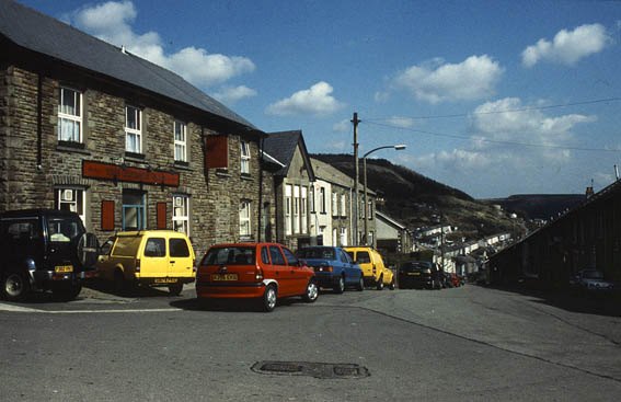
(Photo: GGAT HLCA007)
Cwm Clydach
The historic landscape area of Cwm Clydach encompasses the settlements of Clydach Vale and Blaen Clydach, and Penpant Clydach and the sites of associated collieries. The area formed part of the farms of Blaen Clydach, Pwllyrhebog, Ffynnon-dwym, and Penpant Clydach at the time of the initial industrial development (Tithe map of Ystradyfodwg 1844) during the 1860s and 70s. By 1875 the 'fragmented' first phase colliery settlement of isolated rows had been established at Cwm Clydach, (such as Cwm Clydach Cottages or Bush Houses), while three collieries are also in evidence at this time: Cwm Clydach Colliery and coke ovens, opened 1864 and closed in 1895; Blaen Clydach Colliery, opened by Mr Bush and Company in 1875 (earlier Levels had been opened by Frank James in 1863); and Clydach Vale Colliery, sunk from 1872 by Samuel Thomas and J Osborne Riches, later known as the Cambrian, closed 1966 (1st edition 6-inch OS map 1885, surveyed 1875; Carpenter 2000). Other industrial sites include the Blaenclydach Colliery Company's Blaenclydach Drift Mine (or Gorki Drift Mine) opened in 1912 and also Brookvale and Nant Rhondda Collieries. A network of railways, tramways and inclines, evolved to serve the area's collieries. During the late 1850s the Taff Vale Railway constructed a branch line to serve the Clydach Valley and its collieries. While the Pwllyrhebog Incline (1863-1951) was constructed by the Cwmclydach Colliery Company to link up to the Taff Vale Railway and the Ely Valley Railway Company extended its line from Penygraig to the Cambrian Collieries in 1877.
The grid layout street pattern of Clydach Vale, Blaen Clydach and Penpant Clydach is in place by the end of the 19th century, including High Street, Marian Street, Howard Terrace, Murton Terrace and Park Terrace, Clydach Vale and the linear terraces with gardens of Court, Thomas, Maddox and Charles Streets and Clydach Road, Blaen Clydach, to name a few. Blaen Clydach has a church, chapels and a smithy at this date, while Clydach Vale has in addition to chapels, schools, a Post Office and the large New Inn Hotel town (2nd edition 6-inch OS plan, 1901, revised 1898). It is noticeable that this second phase settlement generally comprises houses built for property investors and/or speculative ventures in the area, however there is a prevalence of houses constructed by building-clubs of colliery workers at Clydach Vale and the Cambrian Colliery.
The settlement is thus largely established by the end of the 19th century with only minimal infilling, the construction of new schools and some additional terraces evident before the outbreak of World War I, including Oak Street, Francis Street and Brynhyfryd Street, above Clydach Vale and Blaen Clydach to either side of Nant Cae-Dafydd (1921 edition 6-inch OS map, surveyed in 1914-15). The creation of the urban landscape as we see it today is very rapid, taking less than 25 years.