Historic Landscape
Characterisation
Merthyr Tydfil
074 Blaen-Canaid and Hendre-Fawr
HLCA 74 Blaen-Canaid and Hendre-Fawr Relict agricultural landscape of small irregular evolved enclosure pattern and associated early post-medieval farmsteads; prehistoric funerary and ritual landscape; important historical and religious associations; Ancient Woodland and 20th century regeneration.
Click here for a
character area map
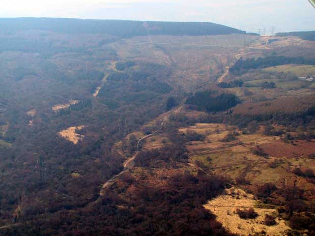
(Photo: GGAT Merthyr 074)
Blaen-Canaid and Hendre-Fawr character area: post-medieval agricultural
landscape of small irregular enclosures and associated farmsteads.
Summary
A relict post-medieval agricultural landscape characterised by small irregular enclosures and associated farmsteads, probably with medieval precursors, now dominated by 20th century forest plantation (including remnant Ancient Woodland). It has important historic and religious associations as a centre of early 17th century religious dissent..
Historical background
The historic landscape area of Blaen-cannaid and Hendre-fawr comprises a largely post-medieval agricultural landscape, part of the Dynevor Estate of the mid- 19th century. The area, which contains important tracts of Ancient Woodland, has seen extensive woodland regeneration and afforestation during the 20th century. The agricultural landscape is characterised by irregular evolved field pattern of small enclosures, and associated early post-medieval farmsteads, Blaen-canaid and Hendre-fawr (mined). The farmsteads, both depicted on Yates's map of 1799 are thought to have had medieval precursors, while relict field system(s) in the area indicate a long agricultural tradition. The name of Hendre-fawr has the 'hendre' element indicative of long established agricultural use probably dating to the medieval period. The hendre was the old or main (winter) settlement of an established medieval agricultural holding, often associated with the 'hendre-hafod system of transhumance agriculture with its traditional movement of dairy herds and farming families to outlying pastures and associated temporary dwellings during the summer months. The holding of Blaen-canaid had a small woollen mill, Melin Ganaid on the banks of the Canaid Brook; the structure is depicted on Yates's map of 1799 as Canode Mill, depicted on later maps including all three editions of the 6-inch OS maps (1875-1915) and considered to be of 17th century date. The area has important non-conformist associations (see also HLCA 069): Blaen-canaid farmhouse being the site of early 17th century Dissenter meetings (sources vary between c 1620 and c 1642).
A number of Bronze Age Cairns or burial mounds are ranged along the crest of the high ground along the western boundary of the area, indicating a traditional boundary of some antiquity. These sites, currently within dense forestry plantations, include the scheduled site of Garn Las (SAM Gm236) on Twyn Gwersyllfa and Cam Castellymeibion (Prn 00490m) to the south, a good example of a ring cairn.
The area also contains geographically discrete groups of industrial extractive features, mostly levels but also shafts and quarries detailed on the 1875 1st edition 6-inch OS map, though probably of early 19th century date. Apart from two sites to the west of Blaen-canaid, a small quarry and level, the majority of the industrial features of the area form a distinctive concentration ranged along and just within the northern boundary of the area and the forestry plantation. Formerly this area was part of the extensive mineral leasehold of the Crawshays of Cyfarthfa within Upper Cwm-glo (see HLCA 064). The concentration of workings is indicative of a boundary adjustment in the area following late 20th century afforestation, and as a result is not considered generally characteristic of the wider area.