Historic Landscape
Characterisation
Merthyr Tydfil
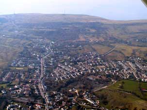
068 Heolgerrig and Pen-yr-Heolgerrig
HLCA 68 Heolgerrig and Pen-yr-Heolgerrig Industrial squatter settlement of irregular pattern, early linear ribbon development supplemented by terraces and housing estates; religious, funerary and ritual features, ie non-conformist chapels; small undeveloped commercial function; industrial extractive and transport features; minor agricultural features.
Summary
An industrial village which evolved from an irregular squatter settlement with early ribbon development of terraced cottages, and a shop, post-office, school and public house.
Historical background
The historic landscape area of Heolgerrig and Pen-yr-Heolgerrig comprises an industrial village settlement, which evolved from a haphazard 'squatter' settlement of irregular dispersed holdings west of Pen-yr-Heolgerrig and the Cwm-glo (Cwmdu) - Cyfarthfa Tramroad. The original 18th century 'squatter' settlement (Penerheol Graig in 1799) lay on the edge of the open mountain and comprised an irregular dispersed scatter of holdings similar to that at Ochr-y-Mynydd (see HLCA 065). By 1850, the settlement had expanded in characteristic ribbon fashion with early linear development of terraced cottages with associated geometric enclosures (allotments). Further ribbon development had occurred by 1875 in the area north of Abernant Gwenith, between Penyrheol (Pen-yr-heolgerrig Farm) and Heol Genig, forming the commercial, social and religious nucleus of the later settlement. The 1875 6-inch OS map indicates the ribbon core of the village had a post office and public house, the Six Bells, with its associated brewery, while 2nd edition of 1905 indicates that an infant school had been added, and later a primary school. Non-conformist chapels, such as Salem Independent Chapel with its school built before 1875 and a Baptist chapel built by 1915, were and still are characteristic features of the area. Later additions include early 20th century terraces at Heolgerrig and later 20th housing estates and recent infilling.
The settlement area encompassed a number of industrial features primarily the course of various tramroads, which connected the area's workings with the Iron Furnaces at Cyfarthfa and Ynys Fach. These included the Cwm-glo (Cwmdu) - Cyfarthfa Tramroad and the Mynydd Aberdare (Winch Fawr) - Cyfarthfa Tramroad, other industrial features included pits, shafts, levels associated spoil heaps and airshafts; these features were all largely in place by 1826, and are detailed on the 6-inch OS maps of 1875-1915.
