Historic Landscape
Characterisation
Merthyr Tydfil
044 Morlais Castle Quarries
HLCA 44 Morlais Castle Quarries Industrial extractive landscape:
large imposing limestone quarries associated with the Penydarren and Dowlais
Iron Works, associated tramroad corridors.
Click here for a
character area map
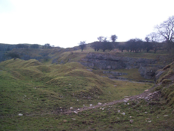
(Photo: GGAT Merthyr 044)
Morlais Castle Quarries character area: extractive landscape of limestone
quarries.
Summary
An industrial extractive landscape of early 19th century date characterised by limestone quarries with associated tips, a lime kiln, and the tram roads which linked the quarries with the Penydarren and Plymouth Ironworks.
Historical background
The historic landscape area of Morlais Castle Quarries comprises a dramatic and important extractive landscape based on the early 19th century quarries associated with Penydarren and Dowlais Ironworks, on land leased from the Earl of Plymouth from 1763. Leases indicate that part of the area was leased to the Dowlais Iron Company (Isaac Wilkinson and John Guest) from 1763/65, while leases of 1810 and 1819 illustrate the connection of the Plymouth Iron Company (the Hill family) to the area.
In 1793, the Morlais Tramroad of the Penydarren, Dowlais and Plymouth Ironworks was constructed (Goitre Lane). Cartographic evidence of 1814 and 1826 shows the lime works west of Morlais Castle connected by the Morlais Tramroad. Between 1814 and 1826 a track connected the eastern quarry area to Pant and the Dowlais Ironworks. A plan attached to a lease of 1848 showed that the area effectively divided in three between the ironworks of Dowlais to the east, Penydarren to the southwest and Plymouth to the northwest. The plan also detailed the line of the Tramroad to the Plymouth (Duffryn Works) and Penydarren Quarries (Goitre Lane) and the Dowlais Railway. The tithe map of 1850 indicates the entire area was the property of Robert Henry Clive and at this date leased to the Dowlais Iron Company.
The OS maps of 1875 to 1915 chart the later development of the quarries, indicating the development of different quarry faces over time and the associated tramroad systems; features include smithies and a limekiln. By 1915 the quarries to the west and north are disused, while that on the east had been extended to the southwest, and largely retained its tramroad system.