Historic Landscape
Characterisation
Merthyr Tydfil
031 Merthyr Common, Central
HLCA 031 Merthyr Common, Central Nationally important Industrial
landscape; water management and extractive features associated with the
Dowlais and Penydarren Ironworks; industrial and post-medieval upland
settlement; transport networks -industrial and public rail; area of industrially
altered common.
Click here for a
character area map
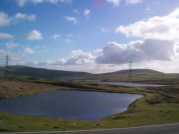
(Photo: GGAT Merthyr 031)
Merthyr Common, Central character area: area of water management features
begun in 1818.
Summary
The central area of Merthyr Common is strongly associated with the development of the iron industry of Merthyr, and indeed of South Wales. It is primarily characterised by water management features associated with the Dowlais Free Drainage System, which single out this landscape as being one of unique importance within the Merthyr Tydfil Historic Landscape, and also of national importance. The area also contains extractive features and transport networks.
Historical background
The historic landscape area of Merthyr Common, Central is a nationally and internationally important landscape created by an upsurge in coal and ironstone extraction from the latter half of 18th century. The area is directly associated with the renaissance in the iron industry, and a result of the introduction of the Cort puddling process, which enabled coke to be used in iron smelting, in place of the traditional charcoal. Coal and ironstone workings in the area came under the direct control of the Iron companies of the region, ie Dowlais and to a lesser extent Penydarren; the Ironwork Company owners holding the mineral leases.
The Dowlais Free Drainage System, an ingenious system of reservoirs and leats dating in part to c 1818, was constructed and embellished over a period of over seventy years to supply water to the coalmines and ironworks of Dowlais. The system, fed by gravity, employed an extensive above-ground network of leats and reservoirs and underground U-shaped channels, built to the 'Dowlais pattern' within various levels, such as the Brew House Level, and Buxton's or the Purple Level, the latter still extant and in good condition as late as the 1960s. The system acted to drain a variety of coal seams including the Lower Four Feet seams of the Cwm-Bargoed, Trecatty and Trehir area and the Upper, and Lower Four Feet, Big Coal, Red, Blue and Sported Vein in the Pantywaun, Rhaslas, and South Tunnel areas. It eventually drained into a water pit at Tyle Dowlais Pit, from where water could either be pumped back to the surface system or allowed to drain to the charging levels of the Penydarren furnaces (Owen 1977, 67-8).
The principal line in the character area was the Great Western & Rhymney Railways' Taff Bargoed Joint Line (c 1876), which projected eastwards to sidings at Fochriw Junction and westwards to the Dowlais Zigzag Lines Junction. The Line then divided, one line preceding to Ivor Works, via the passenger station at Dowlais (Cae Harris), the other, via two reversing junctions (Furnace Tops and Ffos-y-fran) to the Dowlais Works. The mineral branch of the LNWR (opened 1881, closed 1937) from Cwmbargoed Junction to the Cwmbargoed Pits was located within the area. It also contained a section of the Dowlais Iron Company's Railway, together with remains of various associated industrial tramroads and inclines, such as the Penydarren and Bargoed inclines at Tyle Dowlais, and the tramroad and incline to Penydarren Pits.
The area's coal and ironstone workings (predominantly within the adjacent HLCAs 039 and 078) provided the Dowlais Ironworks in particular with a large amount of raw material. Surface workings predominated in the area. This essentially comprised a combination of patching (in use at Tyle Dowlais until the mid-l9th century), small pits of the crown pit type, seen in the vicinity of the Ffos-y-fran Ironworkers' settlement, and where the topography allowed levels driven into the hillsides. Several levels and other features associated with this period are recorded in the northern half of the historic landscape area.
The extraction of ironstone and coal in particular continued throughout the 19th century, fluctuating with economic demand. After the First World War, the extractive industries in the area entered a period of decline, and most of the area's mines had been closed by the end of the 1920s.