Historic Landscape
Characterisation
Merthyr Tydfil
024 Graweth and Pen-y-Lan
HLCA 024 Graweth and Pen-y-Lan Surviving area of post-medieval
evolved irregular small agricultural enclosures with relatively small-scale
industrial influence (coal and iron ore) for the area.
Click here for a
character area map
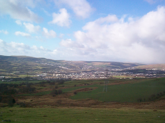
(Photo: GGAT Merthyr 024)
Graweth and Pen-y-Lan character area: agricultural landscape of irregular
enclosures with traditional boundaries and associated farmsteads.
Summary
A post-medieval agricultural landscape, characterised by evolved irregular enclosures with traditional boundaries and associated agricultural holdings. The farmsteads are now abandoned and ruined. This area is remarkable for the relative absence of any industrial features, although some occur on the steeper slopes just above the valley floor.
Historical background
The historic landscape area of Graweth and Pen-y-lan comprises two adjacent post-medieval agricultural holdings, with possible medieval origins, which have survived more or less intact through the industrial era.
The first cartographic reference is of Pen-y-lan in 1814, Graweth is not shown, although both appear on later maps (eg 1826 OS Surveyor's drawing). The farm of Graweth (Grawarth) belonged to a John Llewellyn (1850 tithe map) and was leased to Anthony Hill, owner of the Plymouth Ironworks. The same source gives Jane Taylor as the owner of Penylan. An evolved field pattern, comprising small irregular shaped fields was characteristic of both holdings by this date; that at Graweth indicating a core area of fields around the farmstead, which has at a later date been extended to the north and east taking in areas of 'Waste' or previously unenclosed woodland/mountain pasture, indicated by 'Coedcae' (woodland enclosure), and 'Graig' (rock/crag) field-name elements, with lanes extending from the farm to the unenclosed mountain beyond. A similar development appears to have occurred at Pen-y-lan, where the farmstead lay at the centre of its holding with a 'Waun' (moor or meadow) down slope to the south west, and 'Coedcae' upslope to the northeast. The field pattern of the area remained more or less static during the intervening period, with minor changes, such sub division of the Coedcae, complete by 1875, and the addition of sheepfolds at the boundary of the common. The farmsteads are early post-medieval structures once more characteristic of the locality displaying interesting vernacular features; Graweth for example is a long house of chimney-backing-on-to-entry type, with outside cross passage and fireplace stair.
By 1875, agricultural and domestic features such as the well and sheepfold at Pen-y-lan have been augmented by industrial features at the southern and eastern fringes of the enclosed area, principally (coal and ironstone) levels and airshafts, and a track or tramroad from a kiln in adjacent Nant- yr-Odyn (HLCA 025). The latter track was replaced after 1901 by an inclined tramroad leading from a coal level and associated tips (nearby airshaft) to the mineral railway, near the later Graig Pit. Both the level and tramroad, features associated with renewed exploitation of the area's coal reserves during the First World War, were disused by 1922.
Later industrial activity, dating to some time before 1962, is represented by a group of levels to the north of Penylan just inside the boundary the common, and accessed from the east across the common. By the 1960s, the farms of the area without exception have been abandoned.