Historic Landscape
Characterisation
Merthyr Tydfil
018 Abercanaid and Llwyn-yr-Eos
HLCA 018 Abercanaid and Llwyn-yr-Eos Important surviving example of a mid-l9th century planned industrial settlement; site of early canal side settlement, Llwyn-yr-Eos
Summary
An important surviving example of a 19th century settlement associated with the Graig and Gethin Pits, initially developed by 1850 and substantially extended during the following quarter century. It is characterised by a rectilinear grid of pre-1860s industrial housing, although the early core area has now been demolished and entirely rebuilt..
Historical background
The historic landscape area of Abercanaid and Llwyn-yr-Eos is an important largely intact 1850s ironworks and colliery settlement. The area was initially developed during the 1830s and 40s following the sinking of the Graig and Gethin pits, and associated with an upsurge in production at the Plymouth Iron Works. Like Graig and Upper Abercanaid to the north, the settlement was established adjacent to the Glamorganshire Canal (HLCA 014), which remained an important transport link for the area.
Before the establishment of the settlement, the area comprised woodland and an area of low-lying agricultural fields, which was part of the Dynevor Estate's Abernant Gethin holding.
The early nucleus of the settlement was established by 1850; a strong connection between the adjacent Glamorganshire Canal and the settlement being a notable feature of the period. This comprised a single Row and other cottages fronting the canal and its towpath, while three parallel Rows, ie David Square, Henry Square, and Catherine Square, were arranged at a right angle to it: this early core area has been entirely redeveloped in recent years and a modem estate, Catherine Close, now occupies the area. Llwyn-yr-Eos House was located just to the north, while Gethin Pit No.1 lay at some distance to the south, separated by agricultural land, and Park Square, an L-shaped arrangement of Rows (the latter now demolished) was located beyond (within HLCA 014).
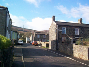
The original settlement had been substantially extended by 1878 with additional Rows fronting the Canal and adjacent road, including the surviving Canal Row. The settlement had been laid out in a regular grid pattern of terraces, with housing comprising comparatively long Rows. The settlement at this time essentially included High Street, River Row (1-6 listed grade II) Nightingale Street (Nos 1-6, 7-12, 70-75, 76-81 all listed grade II), Gethin Street, Cardiff Street, Newton Street, and housing along the west side of Chapel Street. At this date, the settlement contained two Public Houses, the Richard's Arms Public House and the Glamorgan Arms, and two schools and a single chapel, Capel Zion (Independent; 1860). The area between the settlement and the River Taff was largely given over to extensive allotments. Stepping-stones provided access across the River Taff to Pentrebach and the Iron Works. This river crossing was later upgraded to a footbridge, allowing easier access to Abercanaid Station on the Taff Vale Railway, located east of the River.
By 1918/19 the settlement had expanded to fill the area of allotments with the creation of Alexander Place and Donald Street, while the housing along the east side of Chapel Street and the southern end of Gethin Street had been completed. The Church of St Peter and St Paul had also been constructed by this date.
