Historic Landscape
Characterisation
Merthyr Tydfil
007 Dowlais
HLCA 007 Dowlais Industrial settlement: Iron Company owned
settlement with regular and evolved element to layout; initial ribbon
development and unplanned irregular dispersed settlement 'squatter-type'
at Cwm Rhyd-y-Bedd, supplemented by linear grid planned core, public,
educational and religious buildings; extensive 20th century redevelopment;
transport corridor.
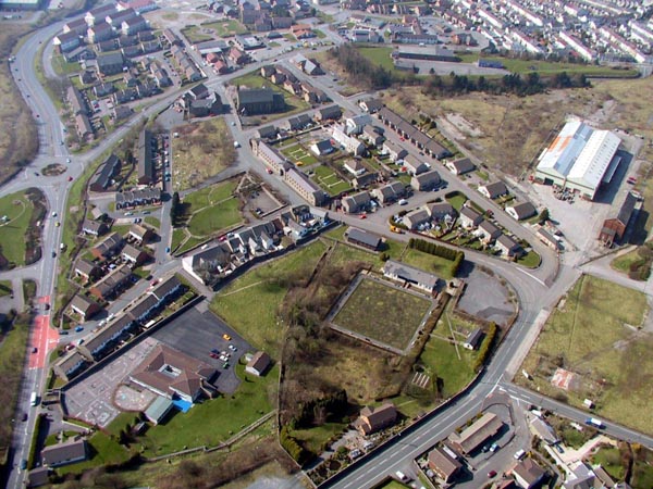
(Photo: GGAT Merthyr 007)
Dowlais character area: early ironworkers' settlement
Summary
The settlement associated with the Dowlais and later Ivor Works. Although it initially started in the second half of the 18th century as a dispersed scatter of cottages, it evolved via several phases of ribbon development to a grid system, which was already partly in place by 1814. Areas of industrial housing survive, but the area as a whole is dominated by imposing public and religious buildings, such as the Dowlais Ironworks Stables and the Memorial Library.
Historical background
The historic landscape area of Dowlais comprised the settlement associated with the Dowlais and later Ivor Works. The settlement developed on the holdings Wern-Llwyn Isaf and Uchaf farms during the latter half of the 18th century. Estate maps of the area (Dowlais Iron Company 1784-1806) provide useful background to the area's early development. The initial settlement comprised a loosely dispersed scatter of cottages, mainly along the road to the Dowlais Iron Works furnaces and in the area immediately north of the furnaces, with a core cluster at the junction of the road from Upper Garth with Nantmorlais (the Cae-Harris area).
By 1814, the settlement was characterised as a linear ribbon development along the road west of Pontgellifaelog to the junction with the lane from Pant, where there was a small nucleus of settlement adjacent to the furnaces, in the area south of the later Dowlais stables.
The characteristic grid system imposed on the settlement was partly in place by the 1820s, with the area to the south of Union Street complete, including a church and the Dowlais stables (1820; site of the first educational facility for workers in Merthyr, established by Josiah John Guest in 1828). Gwern Llwyn Uchaf Farm remained, separated by agricultural land, to the east of the settlement. There was also a scatter of cottages in the area of Morgan Sweet during the period.
Between 1832 and 1850 the settlement at Dowlais underwent major expansion; by the latter date Dowlais comprised linear ribbon development to the south of High Street, while the original core had been extended to include Cae Canol Street. Ribbon development now extended east beyond the junction with Pant Road. The southern area of Dowlais, all Dowlais Iron Company land, had already been laid out in grid fashion. By 1850, this area extended north of High Street as far as Upper Elizabeth Street and the southern end of Victoria Sweet, extending as far as the later station area and the road to Pant. The area included the north side of Ivor Street, where a barracks was located (later replaced by Barrack Row), and Lower and Upper Row. The northwestern area of Dowlais, adjacent to Cwm-Rhyd-y-Bedd belonged to a number of minor landowners and developed slightly different characteristics: notably in its layout. The latter was typified by a scatter of short rows and individual cottages and included the area between Pant Road and the Ivor Iron Works (HLCA 029), Llewellyn Street; Winifred Street and a row to the west of the later Balaclava Road in the area of Pen Cae Eira.
The OS 6-inch and 25-inch First Edition maps (1875 and 1878) provide further detail such as the Dowlais Ironworks stables, Market House, Dowlais Iron Company schools, the Guest Reading Room, Hebron chapel, Dowlais House Lodge, hospital, and Beulah chapel. The area from Victoria Street and Elizabeth Sweet as far north as Francis Street, ie north western Dowlais, had developed in a more tightly-packed fashion with a less regular grid street pattern, perhaps indicating different house provision to the south part of Dowlais where the Influence of the Iron Company on town-planning was clear.
Dowlais was largely complete by 1878, though there was some minor additional development during the period up to 1919, such as Alfonso Terrace and Moulson, Rees and Jones Street.