Historic Landscape
Characterisation
Merthyr Tydfil
002 Williamstown, Cae-Pant-Tywyll, Tydfil's Well and
Morgan Town
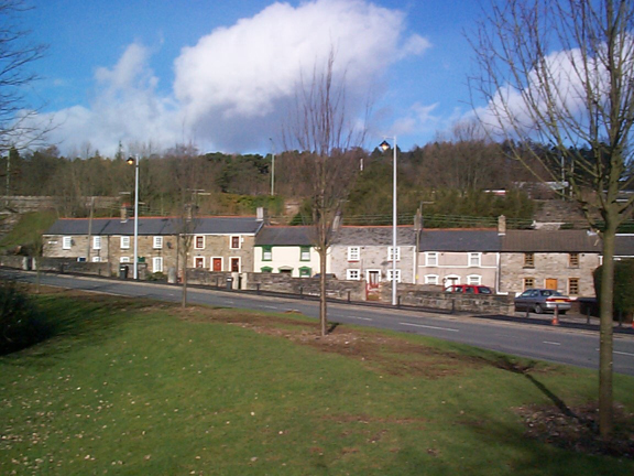
HLCA 002 Williamstown, Cae-Pant-Tywyll, Tydfil's Well and Morgan
Town Well preserved ironworks settlement: early industrial settlement
expansion mixed linear and regular layout, with minor late urban renewal;
minor commercial development; close association with Cyfarthfa Iron Works;
industrial transport corridor.
Click here for a
character area map
(Back to map)
(Photo: GGAT Merthyr 002)
Williamstown, Cae-Pant-Tywyl1, Tydfil's Well and Morgan Town character
area: important early worker's housing and small commercial development.
Summary
The origins of this landscape area lie in the ironworks settlement based around the Cyfartha Iron Works at the end of the 18th century, and was already largely complete by 1836. It contains important examples of early workers' housing and a small but significant commercial development at Morgan Town.
Historical background
The historic landscape area of Williamstown, Cae-Pant-Tywyll, Tydfil's Well and Morgan Town developed at the end of the 18th century, as an ironworks settlement based around the Cyfarthfa Iron Works. The area evolved in relative isolation from the main core of Merthyr Tydfil to the south (HLCA 001), separated by tips in the Abermorlais area.
By 1814, the settlement comprised linear ribbon development along Brecon Road of short rows of cottages to either side, including Castle Square (Pandy Place) and the area opposite, which includes the tollhouse; Quarry Row, Bethesda Street was also in place at this date. Settlement expansion continued ribbon fashion along Brecon Road. Additional features included the Merthyr Brewery and fishpond and the Penydarren Tramroad (see HLCA 019) to the canal head along Bethesda Street.
The settlement was largely complete by 1836 and cartographic evidence shows the settlement in some detail. The settlement comprised Castle Square and Tydfil's Well Sweet (Brecon Road) and Fishpond Sweet; a Tollgate, public houses, eg the Lamb and Flag and the Grawen Arms; chapels, eg Baptist Chapel, and on Quarry Street (Quarry Row) the Merthyr Brewery, with an associated pond, and a tannery.
Minor additions occurred in the period 1836-51 including the construction of the Williamstown Cottages, and the remainder of Morgan Town. Park Row and the Fever Hospital were extant by 1875. Until the end of the 20th century renewal of the lower Cae Pant Tywyll area to the west of Brecon Road, now characterised by modem executive style housing. little change was apparent.