Historic Landscape
Characterisation
Merthyr Tydfil
001 Merthyr Tydfil: Historic and Commercial Core
HLCA 001 Merthyr Tydfil: Historic and Commercial Core Pre-
and early industrial settlement core with later expanded industrial settlement:
pre-industrial religious, commercial and administrative centre developed
during the post-medieval and industrial period; post-medieval, 19th and
20th century religious, commercial, administrative and other buildings;
historic events and associations; industrial transport corridor.
Click here for a
character area map
(Back to map)
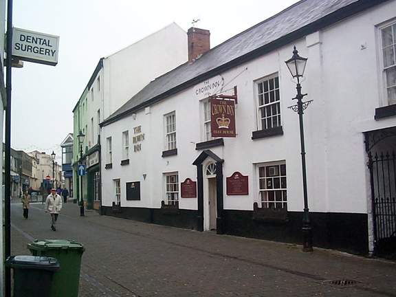
(Photo: GGAT Merthyr 001)
Merthyr Tydfil: Historic and Commercial Core character area: historic
town centre.
Summary
The development of this landscape from the village of Merthyr Tydfil, centred on the medieval church, occurred as the result of the establishment of the first ironworks at the head of the Taff Valley in the middle of the 18th century. From the early 19th century a regular plan and wide straight streets was imposed on the earlier irregular plan of the initial industrial development of the original village. This area contains a few surviving buildings of medieval origin, extensively remodelled at a later date, together with a number of impressive 19th and 20th century civic and religious buildings.
Historical background
The historic landscape area of Merthyr Tydfil: Historic and Commercial Core comprises the commercial and medieval core around the church of St. Tydfil and the primary expansion area of Glebe land, and the development at Twynyrodyn.
Initial urban expansion occurred at the village o f Merthyr Tydfil began following the establishment of the first ironworks at the head of the Taff Valley in 1759-65. The upsurge in development, however, appears to date to the l780s, by which time four ironworks, Dowlais, Plymouth, Cyfarthfa, and Penydarren, were in operation.
The settlement of Merthyr Tydfil initially developed according to the street/road pattern established during the medieval and immediate post-medieval period and by 1799 the area to the south of the Morlais Brook had seen major, if haphazard, urban expansion and was well advanced to becoming a major urban centre. The core area at this time focused on the medieval nucleus of the parish church of St. Tydfil, Maerdy House and the Court House and comprised High Street, Bridge Street, Broad Street, Mill Street, Swan Street, Yew Street, Cross keys Lane and the Upper end of Plymouth Street. The lack of planning in the layout of the ironworkers' settlement, remarked upon by BH Malkin in 1803, was particularly evident in the area to the south and east of St. Tydfil's Church. Here the influence of the organic village layout was strongest. The haphazard layout of this area appears to have survived until the area was cleared during the latter half of the 20th century; it was this area, which contained the highest density, and perhaps the poorest of Merthyr's housing stock.
A major urban redevelopment of part of the area had occurred, however, by 1806, and wide, straight streets were now characteristic and a regular layout had been imposed on the development of the Glebeland area (Malkin 1804; 1808). Cartographic evidence supports this development; by 1813-14 development of the core area included buildings to either side of High Street, particularly in the area of Pontmorlais, the laying out of Castle Street, Cross Street. Glebeland Street. Glebeland Place and Ynysgau Street.
By 1836 with the addition of Clive (later Wellington Street), Thomas (later Victoria Street) and Graham Streets and the Market House, forming a new commercial area to the west of High Street, the core area was more or less complete. The town now boasted numerous non-conformist chapels and churches, numerous public houses, a market place, post office, and the Castle Hotel and Posting House.
Further infilling and urban re-development occurred during the period 1836-1875. The increase in the density of housing to the south and east of the St. Tydfil's Church was a notable feature of the period as was the addition of further terraced rows behind existing streets, such as to north of Castle Street, and between Clive and Bridge Streets. The latter was a direct result of the economic boom years of the 1830s and 40s. The area between Graham Street and Swan Street has also been redeveloped with the insertion of Albert Street to produce a more regular grid pattern. Also striking was the apparent wholesale remodelling of properties fronting onto High Street, including the development of the former rear yard areas; this suggests a change over from a predominantly domestic to predominantly commercial function.
Little further change in the layout of the area occurred until redevelopment of the area to the west of High Street during the 20th century.
As well as containing a few surviving pre-industrial structures such as the Court House (a probable medieval building remodelled during the 18th century) and the 18th century Crown Inn, the area also boasts many of Merthyr's most impressive 19th and 20th century buildings, too many to mention individually here. A small selection might include St. Tydfil's Church (rebuilt 1820-21 later transformed by IL Pearson, 1894-1901, Neo-Romanesque style); St. David's (1846-47 TH Wyatt and Brandon, Early English style); and the Carnegie Library (1935-6 T Edmund Rees).
The area of Twynyrodyn initially developed between 1799 and 1813-14; a feature of the period was linear ribbon expansion up Twynyrodyn Hill, including Coed Cae Court to the north, a chapel and burying ground. The settlement at Twyn-yr-Odyn expanded over the intervening period so that by 1875, additional ribbon development was almost complete along Twyn-yr-Odyn Road and to the south William, Mary and Rees Streets had been added. Dyke Street was added by 1905 just to the west, and by 1918, Hampton Street.