Historic Landscape
Characterisation
The Gwent Levels
09 Green Moor
09 Green Moor character area: simple landscape in the back-fen
of Redwick/Llandevenny/Magor.
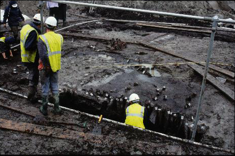
(Photo: GGAT Wilkinson Site Exc3)
The framework of major reens and lanes date to at least the mid-sixteenth century, and probably earlier. However, the pattern of fields is largely post-medieval. The areas north and east of the railway were enclosed first, possibly in the seventeenth or eighteenth centuries; Green Moor proper, south of Llanwern, was enclosed c.1850.
When the Gwent Europark was under construction a nearly complete Roman boat was discovered beside a stone and timber quay.
In the medieval/post-medieval period Green Moor was an extensive common pasture used by many of the surrounding communities.
Key historic landscape characteristics
Uniformity, strong "wetland" feel, regular field pattern,
straight roads (grid-layout), drainage features (reens, ridgeing/surface
drainage, grips and bridges)
The lowest-lying area of back-fen. The southern area bounds the Steel Works, railway and Gwent Europark to the north, Rush Wall (area 8) and Blackwall to the south/east (area 10). The block to the north of the railway retains its original fen-edge.
The principal elements of this very uniform landscape are a very regular pattern of field-boundaries, laid out within a grid of straight roads and major reens. There are few other landscape features and just one settlement (Barland's Farm). Certain areas have good grips and some fine bridges (e.g. along Rush Wall). A duck decoy pond is documented at ST 416 862.
The condition of this landscape is mixed. To the east and north of the Gwent Europark, most boundaries survive, fields retain surface ridging, and fragmentary hedges contain a large number of mature willows; this landscape has a strong wetland feel, typical of low-lying back-fen areas. The area south of the Steel Works has been used an ash tip.
The area south of Magor village is now a nature reserve, run by the Gwent Wildlife Trust. Traditional management methods preserve areas of rich meadow and "fen carr" vegetation.
Though once a common type of field pattern, the distinctively homogeneous
back-fen landscapes are now rare. Areas north and east of the Gwent Europark
are typical, in good condition and retain the original fen-edge. There
are fine views of the adjacent uplands, though the area south west of
Llandevenny village is over-shadowed by the Gwent Europark. Overall, the
eastern and northern areas have a very high integrity and coherence.